
|
|
2009 Edition Part 2 Figure 2A-3. Examples of Locations for Some Typical Signs at Intersections
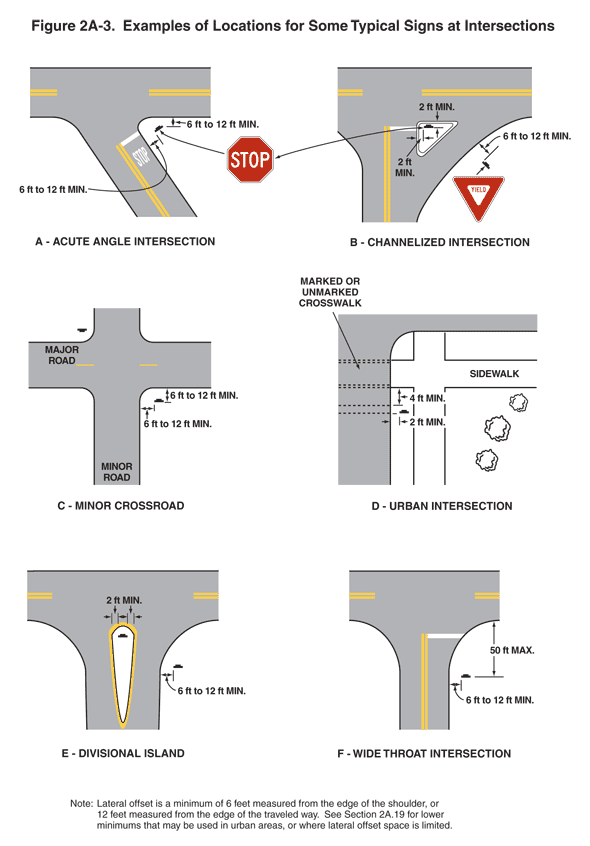
Figure 2A-2. Examples of Locations for Some Typical Signs at Intersections
This figure shows six examples labeled A through F of locations for signs at intersections.
A is labeled "Acute Angle Intersection" and shows a STOP sign placed on the stem of an acute angle intersection that is T-shaped. The distance from the edge of the road along the top of the T to the nearest edge of the STOP sign is shown as a dimension of 6 ft to 12 ft MIN. The distance from the edge of the road on the stem of the T to the nearest edge of the STOP sign is shown as a dimension of 6 ft to 12 MIN.
B is labeled "Channelized Intersection." The intersection is T-shaped, with a channelized right-turn lane on the stem of the T, separated from the perpendicular portion of the road on the stem of the T by a triangular-shaped channelizing island. A STOP sign facing the stem of the T is shown on the triangular island. The distance from the edge of the island closest to the perpendicular portion of the road on the stem of the T to the nearest edge of the STOP sign is shown as a dimension of 2 ft MIN. The distance from the edge of the island closest to the road along the top of the T to the nearest edge of the STOP sign is shown as a dimension of 2 ft MIN. A Yield sign is shown to the right of the channelized right-turn lane facing traffic on that right-turn lane as it approaches the road along the top of the T. The distance from the edge of the channelized right-turn lane to the nearest edge of the Yield sign is shown as a dimension of 6 ft to 12 ft MIN.
C is labeled "Minor Crossroad." The intersection is shown with four legs. The east-west road is denoted as the major road, and the north-south road is denoted as the minor road. Signs are shown on the northwest and southeast corners of the intersection, facing to the north and south, respectively. The distance from the edge of the major road pavement to the near edge of the sign on the southeast corner and the distance from the edge of the minor road pavement to the near edge of the same sign are both shown as a dimension of 6 ft to 12 ft MIN.
D is labeled "Urban Intersection" and shows the southeast corner of an urban intersection. Sidewalks are shown parallel to the east-west road and parallel to the north-south road. Both sidewalks are separated from the road edges by an undimensioned distance. The projection of the east-west sidewalk across the north-south road is denoted as a "marked or unmarked crosswalk." A sign is shown on the south leg of the intersection, facing northbound traffic. The distance from the southernmost edge of the marked or unmarked crosswalk to the sign is shown as a dimension of4 ft MIN. The distance from the edge of the north-south road to the near edge of the sign is shown as a dimension of 2 ft MIN.
E is labeled "Divisional Island"and shows a divisional island at a T-shaped intersection. The divisional island is shown in the middle of the roadway that is the stem of the T. A sign is shown on the right side of the roadway that is the stem of the T, facing northbound traffic. The distance from the nearest edge of that sign to the edge of the pavement of the north-south road is shown as a dimension of 2 ft MIN. A sign is also shown on the divisional island, near the north end of the island. The distances from either edge of that sign to either edge of the divisional island are both shown as a dimension of 6 ft to 12 ft MIN.
F is labeled "Wide Throat Intersection" and shows a T-shaped intersection. The north-south road, which is shown as the stem of the T, is shown with a stop line across the northbound lane. A sign is shown on the southeast corner of the intersection, facing northbound traffic. The distance from the edge of the east-west road (the top of the T), at the point where the southeast corner radius meets the tangent section of the east-west roadway, to the sign is shown as a dimension of 50 ft MAX. The distance from the edge of the north-south roadway to the nearest edge of the sign is shown asa dimension of 6 ft to 12 ft MIN.
A note at the bottom of the figure states "Lateral offset is a minimum of 6 feet measured from the edge of the shoulder, 12 feet measured from the edge of the traveled way. See Section 2A-19 for lower minimums that may be used in urban areas, or where lateral offset space is limited."