
|
|
2009 Edition Part 2 Figure 2A-4. Relative Locations of Regulatory, Warning, and Guide Signs on an Intersection Approach
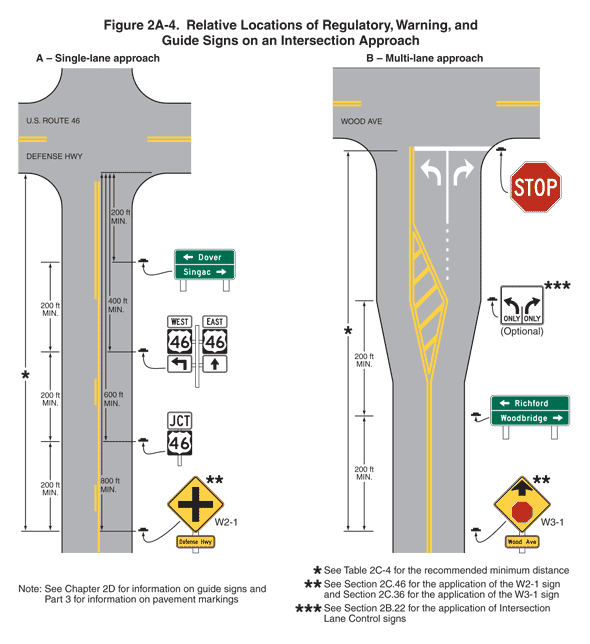
Figure 2A-4. Relative Locations of Regulatory, Warning, and Guide Signs on an Intersection Approach
This figure shows two examples of relative locations of regulatory, warning, and guide signs on an intersection approach.
A note states "See Chapter 2D for information on guide signs and Part 3 for information on pavement markings."
The first example is labeled "A – Single-Lane Approach." It shows a roadway running vertically and intersecting a roadway running horizontally labeled "U.S ROUTE 46 DEFENSE HWY." The vertical and horizontal roadways are shown with one lane of traffic in each direction. Near the intersection, the opposing lanes are shown separated by a solid double yellow line. Farther away from the intersection on the vertical roadway, the opposing lanes in each direction are shown separated from each other by a broken yellow line to the left of the southbound lane and a solid yellow line to the left of the northbound lane.
There are four sign assemblies shown on the vertical highway, all shown on the right side of the highway:
- At the bottom of the figure, a sign assembly is shown composed of a W2-1 diamond-shaped yellow sign with a black border and a black cross mounted above a horizontal rectangular yellow plaque with a black border and the words "Defense Hwy" in black. A note states "See Section 2C.46 for the application of the W2-1 sign." This sign assembly is shown as a dimensioned distance of 200 ft MIN. in advance of the next sign assembly and 800 ft MIN. in advance of the near side of the intersection. A note states "See Table 2C-4 for the recommended minimum distance."
- Closer to the intersection, the second sign assembly is shown composed of a horizontal rectangular white "JCT" junction sign mounted above a square black sign with the numeral "46" displayed on a U.S. route white shield. This sign assembly is shown as a dimensioned distance of 200 ft MIN. in advance of the next sign assembly and 600 ft MIN. in advance of the near side of the intersection.
- Closer to the intersection, the third sign assembly is shown composed of six signs. On the left side of the assembly, a white horizontal rectangular sign is shown with the word "WEST" that is mounted above a square black sign with the numeral "46" displayed on a U.S. route white shield is shown above a horizontal rectangular sign with a right-angle black arrow pointing up and to the left on a white background. On the right side of the assembly, a white horizontal rectangular sign is shown with the word "EAST" that is mounted above a square black sign with the numeral "46" displayed on a U.S. route white shield that is mounted above a horizontal rectangular white sign with an upward-pointing vertical black arrow. This sign assembly is shown as a dimensioned distance of 200 ft MIN. in advance of the next sign assembly and 400 ft MIN. in advance of the near side of the intersection.
- Just prior to the intersection, a horizontal rectangular green sign is shown with a left-pointing horizontal arrow to the left of the word "Dover" on the top line and the word "Singac" to the left of a right-pointing horizontal arrow on the bottom line. This sign assembly is shown as a dimensioned distance of 200 ft MIN. in advance of the near side of the intersection.
The second example is labeled "B – Multiple-Lane Approach." It shows a roadway running vertically and forming a T-shaped intersection with a roadway running horizontally labeled "WOOD AVE." The vertical and horizontal roadways are shown with one lane of traffic in each direction. Near the intersection, the opposing lanes are shown separated by a solid double yellow line.
This figure shows the vertical and horizontal two-lane roadways with one lane of traffic in each direction. The opposing lanes are shown separated by a solid double yellow line. A solid white stop line is shown across the northbound lane at the intersection on the vertical roadway. Midway on the vertical roadway, the roadway is shown widening and angling out on the left and right to accommodate the addition of a third lane. At the point where the roadway begins to widen, the solid double yellow line is shown forming a Y-shaped island in the center of the roadway, filled with diagonal yellow stripes. At the top of the Y shape, a dotted white line is shown separating the two northbound lanes. The solid double yellow line to the right of the northbound lanes then is shown angling to the left to join the reform one double line that continues to the white stop line. The dotted white line between the two northbound lanes is shown changing to a solid white line just in advance of the white stop line. A white left-turn arrow is shown marked in the left northbound lane, and a white right-turn arrow is shown marked in the right northbound lane.
There are four sign assemblies shown on the vertical highway, all shown on the right side of the highway:
- At the bottom of the figure, a sign assembly is shown composed of a W3-1 diamond-shaped yellow sign with a black border and a short upward-pointing black arrow above a STOP sign symbol mounted above a horizontal rectangular yellow plaque with a black border and the words "Wood Ave" in black. A note states "See Section 2C.36 for the application of the W3-1 sign." This sign assembly is shown as a dimensioned distance of 200 ft MIN. in advance of the next sign assembly. For the distance from this sign assembly to the near side of the intersection, a note states "See Table 2C-4 for the recommended minimum distance."
- Closer to the intersection, a horizontal rectangular green sign is shown with a left-pointing horizontal arrow to the left of the word "Richford" on the top line and the word "Woodbridge" to the left of a right-pointing horizontal arrow on the bottom line. This sign assembly is shown as a dimensioned distance of 200 ft MIN. in advance of the next sign.
- The third sign is shown opposite the island formed by diagonal yellow stripes at the point where the roadway widens and the left and right northbound lanes begin. This sign is shown as a horizontal rectangular white sign with a black border and legend. On the left half of the sign, a vertical black arrow is shown curving up and to the left above the word "ONLY." A short black vertical line is shown to its right. On the right half of the sign, a vertical black arrow is shown curving up and to the right above the word "ONLY." This sign is marked as optional. A note states "See Section 2B.22 for the application of Intersection Lane Control signs."
- The fourth sign is shown as a STOP sign at the white stop line at the intersection with the horizontal roadway.