
|
|
2009 Edition Part 2 Figure 2B-9. Examples of Applications of Jughandle Regulatory and Guide Signing (Sheet 1 of 3)
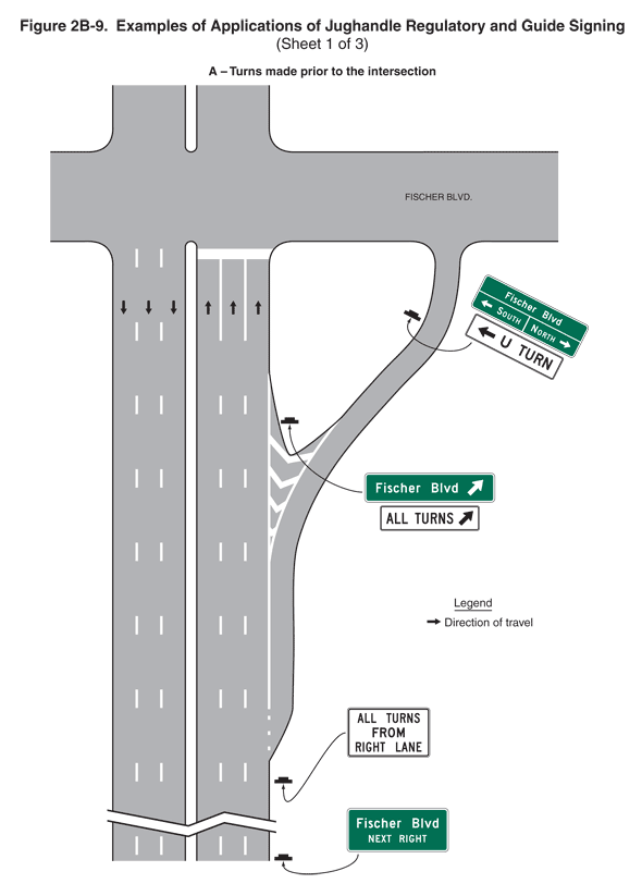
Figure 2B-9. Examples of Applications of Jughandle Regulatory and Guide Signing (Sheet 1 of 3)
This figure illustrates three examples of applications of jughandle regulatory and guide signing on three sheets: turns made prior to the intersection, a traditional jughandle, and turns made beyond the intersection.
Sheet 1 illustrates turns made prior to the intersection. It shows a segment of a vertical six-lane divided highway intersecting a horizontal roadway, labeled "Fischer Blvd.". Black arrows on the vertical roadway indicate that the direction of travel in the three left lanes is southbound and in the three right lanes, it is northbound. Broken white lines are shown separating the lanes on the vertical highway. A solid white line is shown extending across the three northbound lanes in advance of the intersection with the horizontal roadway. Black inverted Ts denote signs.
Near the bottom of the figure, a deceleration lane tapers to the right of the northbound lanes, leading to a right exit ramp. The deceleration lane runs parallel to the right lane and is separated from it by a dotted white line that changes to a solid white line. Along the top third of the exit lane, the solid white line splits in two to form a V-shaped island with forward-pointing white chevron markings on the pavement. The exit ramp then curves to the right and then becomes vertical to join the horizontal roadway, Fischer Blvd.
At the bottom of the figure, a sign is shown to the right of the northbound lanes. It is shown as a horizontal rectangular green sign with a white border and legend with the words "Fischer Blvd NEXT RIGHT" on three lines.
At the point where the taper into the deceleration lane begins, a sign is shown to the right of the roadway. It is shown as a horizontal rectangular while sign with a black border and legend with the words "ALL TURNS FROM RIGHT LANE" on three lines.
Beyond these signs, at the point where the island ends, a sign assembly is shown to the right of the right northbound lanes. It is composed of a horizontal rectangular green sign with a white border and legend with the words "Fischer Blvd" to the left of a diagonal arrow pointing up and to the right. It is mounted above a horizontal rectangular while plaque with a black border and legend with the words "ALL TURNS" to the left of a diagonal arrow pointing up and to the right.
Farther along the exit ramp and in advance of the horizontal roadway, a sign assembly is shown to the left of the exit ramp. It is composed of a horizontal rectangular green sign with a white border and legend divided in half vertically by a white line. Above the dividing line, the words "Fischer Blvd" are shown. Below the dividing line, the bottom half of the sign is divided in half horizontally by a white line. To the left of that line the word "South" is shown to the right of a short horizontal arrow pointing to the left. To the right of the line the word "North" is shown to the left of a short horizontal arrow pointing to the right. This sign is shown mounted above a horizontal rectangular white plaque with a black border and legend. A short horizontal arrow pointing to the left is shown to the left of the words "U TURN."