 |
PDF Version, 1.4MB
PDF files can be viewed with the Acrobat® Reader®.
September 27, 2011
Bruce Friedman, PE, PTOE
Federal Highway Administration
Office of Transportation Operations, HOTO-1
1200 New Jersey Avenue, SE Mail Stop: E86-201
Washington, DC 20590
RE: Request for Permission to Experiment with a Bicycle Priority Shared Lane
Dear Mr. Friedman:
The City of Boston is submitting the attached request for permission to experiment with a bicycle priority shared lane to evaluate its potential effectiveness modifying bicyclist and motorist behavior on Brighton Avenue. It is the City of Boston's goal to increase rates of bicycling and to improve bicyclists' comfort and safety operating on Boston roadways.
The following application includes a statement of the problem, summary of proposed improvements and other information requested under Section 1A.10 (Interpretations, Experimentations, Changes, and Interim Approvals) of the Manual on Uniform Traffic Control Devices for Streets and Highways (MUTCD). The City of Boston is being assisted by Toole Design Group and Northeastern University to conduct a detailed evaluation of before and after conditions to evaluate the effectiveness of a bicycle priority shared lane.
Thank you for considering this request to experiment with an innovative treatment to improve bicycle safety in Boston, Massachusetts. If you have any questions or need additional information, please contact Nicole Freedman with the City of Boston Bicycle Program at 617-918-4456 or by emailing Nicole.Freedman.bra@cityofboston.gov.
Sincerely,
Thomas Tinlin
Commissioner of Boston Transportation Department
Request for Permission to Experiment
A. Background and Nature of the Problem
The City of Boston is seeking to improve the safety and comfort of bicycling on its public roadways and to increase rates of bicycling within the City.
The City has an expanding network of on-road bicycle lanes and marked shared lanes to complement an older system of existing shared use paths. Within the city of Boston, the Allston/Brighton neighborhood is a local and regional destination with a balance of daytime and evening activities for shopping, dining, and entertainment establishments, as well as a significant student population. The majority of the commercial district lies along Brighton Avenue (an east/west corridor) and Harvard Avenue (a north/south corridor).
Brighton Avenue is a median divided arterial roadway located in the Allston/Brighton neighborhood of the City of Boston. The roadway location within the City of Boston is provided in Figure 1 with Brighton Avenue Highlighted in magenta. The brighton Avenue project limits are Cambridge Street to the west and Commonwealth Avenue to the east. Both adjacent roadways have existing bicycle lanes as well as Harvard Avenue, which intersects Brighton Avenue as shown in Figure 1. A cross section of Brighton Avenue is shown in Figure 2. As shown, Brighton Avenue within the study area is a four lane divided roadway with left turn lanes and adjacent 0n-street parking. The segment is approximately 3,300 feet in length and carries approximately 21,000 - 30,000 vehicles per day within the project limits. Full-time parking (time limited to two hours) is present on both sides of the roadways as well as loading zones and bus stops.
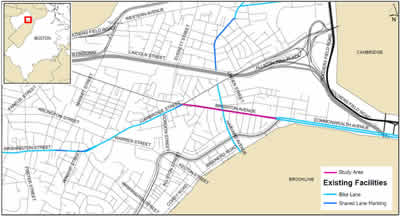
Figure 1 – Locus Map of Brighton Avenue
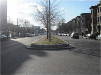
Figure 2 – Brighton Avenue typical section
Presently bicyclists are observed operating on Brighton Avenue in a variety of manners:
The City desires to improve bicycling behavior, safety, and comfort of bicyclists throughout Boston, and this roadway segment is an important destination and critical link in the developing bicycle network. The existing curb to median width is typically 32 feet. Current MUTCD guidelines limit pavement marking options within the corridor to the following two choices – narrow travel lanes and parking lane to stripe bicycle lanes (cross section would reflect the minimum widths for all lanes), or provide shared lane markings within an existing travel lane.
Due to the loading, traffic volumes, parking turnover and narrow curb to median width, a bicycle lane may not be the most effective design as it will be located largely in the zone of potentially opening parked vehicle doors.
The shared lane marking was developed as a tool to guide bicyclist operation within shared travel lanes in situations such as these. On roadways with lane widths narrower than 14 feet, the intent is to have bicyclist's operate near or at the center of the lane to control the lane. This will require motorists to travel behind the bicyclist or to change lanes to pass them safely.
Recent research has shown that the effectiveness of the shared lane marking may be limited in modifying bicyclists' position within a travel lane on roadways with higher volumes and speeds of motorized traffic, such as the conditions on Brighton Avenue. If bicyclists do not take the lane, they will be passed within the lane potentially at unsafe distances by motorists, risking injury and decreasing their comfort operating on the roadway. The City is concerned that the shared lane marking alone may not accomplish the goals to increase rates of bicycling and to improve bicyclists' safety and comfort.
B. Proposed Changes not in Conformance with Existing MUTCD
Recent approved research completed in Salt Lake City, UT, Brookline, MA, and Long Beach, CA has shown potential benefits for a traffic control device known as a "bicycle priority shared lane". The device consists of a combination of shared lane markings supplemented by either a continuously marked green "bicycle lane" or a series of dotted white traffic lines bracketing the shared lane marking (See Figure 3). Both treatments are applied within the center of the right most travel lane and can be accompanied by warning or regulatory traffic signs.
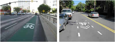
Figure 3 – Priority Lanes in Salt Lake City (left) and Brookline (right)
The City of Boston is proposing to install a bicycle priority shared lane on Brighton Avenue to determine if this is a more effective treatment to guide bicycle traffic on higher volume, multi-lane roadways where bicycle lanes are not feasible.
A bicycle priority shared lane is not presently included in the latest edition of the MUTCD.
C. Description of Proposed Experiment and Devices
The City is proposing a phased before/after observational study to determine the effectiveness of various bicycle priority shared lane treatments. It is theorized that more frequent placement of markings (Brookline) or continuous markings (Salt Lake City, Long Beach) will result in the desired bicyclist and motorist operation. It is also theorized that vehicle lane width has an important influence on behavior. A desirable travel lane of 10 feet will naturally induce bicyclist operating in the lane in such as a manner that motorists will have to change lanes to pass them.
The proposed experiment includes the following four phases:
The proposed experiment phasing is shown in Figure 4.
To determine the effect of lane width on the operating characteristics of the treatments, the experiment will be divided into two segments. The westbound portion of the roadway will maintain the existing 20 foot parking/travel lane to evaluate operating characteristics in the resulting 12 foot travel lane. The eastbound portion of the roadway will be maintain the existing 20 foot parking/travel lane, however the parking lane will be striped as 9 feet to evaluate operating characteristics in the resulting 11 foot travel lane.
If it is determined that additional signs and/or pavement markings may be necessary, FHWA will be notified of the proposed change to the experiment.
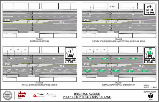
Figure 4 – Proposed Experiment Phasing
D. Supporting Data for Use of Devices
The proposal to use these markings follows the experimental procedure set forth in Section 1A.12 of the MUTCD. The proposals are based upon previously FHWA approved research in Long Beach, California and Salt Lake City, Utah. We have also reviewed research submitted to the Transportation Research Board for the bicycle priority shared lanes in Brookline, MA.
The MUTCD does not presently allow the establishment of a bicycle lane within a general purpose travel lane, nor does it allow the use of green color within a travel lane.
The MUTCD does not permit the use of a shared lane marking and the R4-11 sign, both of which will be installed per the guidelines of the MUTCD.
The MUTCD does not permit the use of the two variations of the signs proposed as part of the experimental treatments.
The use of a supplemental plaque advising travelers to CHANGE LANES TO PASS is allowed per Section 2B.02 of the MUTCD.
E. Patent or Copyright Protection
The devices proposed for used are not protected by patent or copyright.
F. Time Period and Location of Experiment
It is anticipated that the experiment will be phased over the fall of 2011 and spring and summer of 2012. Observational analysis will be conducted at one midblock location between Cambridge Street and Commonwealth Avenue on both sides of the median. The following outline describes the process for the experiment and the estimated length of time for each phase.
G. Research and Evaluation Plan
The City of Boston is collaborating with Toole Design Group and Northeastern University to study the effectiveness of the proposed treatments. The project will involve "before" and "after" studies tracking progress of the experiment and evaluate the performance of the new facilities.
It is anticipated that digital video will be collected at the chosen observation locations. It is expected that a minimum of 150 bicycle observations will be collected during one of the following time periods for each observation:
All vehicles and bicyclists that operate on the roadway, including the adjacent sidewalks, will be counted during data collection efforts. Lane utilization, passing method, passing distance, sidewalk riding, and direction of travel will be documented for each stage of the experiment. Observations of conflicts will be noted.
H. Agreement to Restore Site to Conform to the MUTCD
If it is determined the devices do not achieve the goals outlined herein, they will be removed at the conclusion of the experiment process.
Should at any time during the experiment the safety of users of the roadway become a concern due to treatments associated with this experiment, the City of Boston is willing to terminate the experiment and restore the site to its original condition.
I. Progress Reports
The City of Boston will submit semi-annual reports on the experiments progress and within three months of the completion of the experiment a final report.
J. Conclusion
The objective of the study is to determine a cost effective treatment to encourage higher rates of bicycling on roadways without bicycle lanes in a safe manner.
Should the results of this experiment conclude that some or all of the treatments contained in this proposal are effective and successful in improving bicyclist's safety, the FHWA should consider a guideline for the traffic control devices in a future update of the MUTCD.
|
United States Department of Transportation - Federal Highway Administration |
||