
2009 Edition Part 2 Figure 2D-9. Examples of Guide Signs for Roundabouts (Sheet 1 of 2)
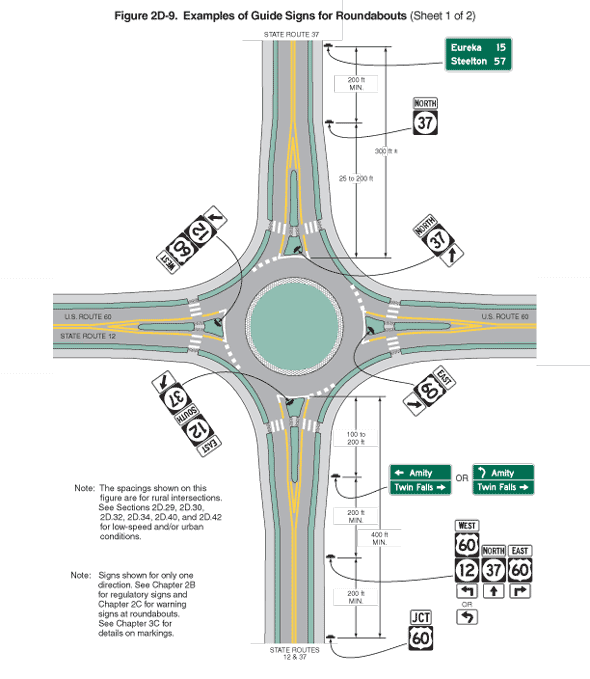
Figure 2D-9. Examples of Guide Signs for Roundabouts (Sheet 1 of 2)
This figure illustrates examples of guide signs for roundabouts.
Sheet 1 shows guide signs placed to the right of the roadway approachways to the roundabout and placed on splitter islands circling the roundabout.
Two notes are shown. The first note states: "The spacings shown on this figure are for rural intersections. See Sections 2D.29, 2D.30, 2D.32, 2D.34, 2D.40 and 2D.42 for low-speed and/or urban conditions." The second note states: "Signs shown for only one direction. See Chapter 2B for regulatory signs and Chapter 2C for warning signs at roundabouts. See Chapter 3C for details on markings."
The figure shows a green central island surrounded by a circular roadway. A narrow band shown as composed of a contrasting pavement texture separates the island from the circular roadway.
Four roadways enter the roundabout from the north, south, east, and west. Each roadway is a two-lane road. The roadway entering from the north is labeled "State Route 37." The roadway entering from the east is labeled "U.S. Route 60." The roadway entering from the south is labeled "State Routes 12 and 27." The roadway entering from the west is labeled "U.S. Route 12," and the roadway exiting to the west is labeled "U.S. Route 60." Concentric bands of narrow landscaping buffers and curbing border the outsides of the roadways. A triangular splitter island separates the two lanes of each road where it intersects the circular roadway. Around the outer edge of the circular roadway, a solid white line is shown across the base of each splitter island, a dotted white line is shown intersecting each of the four entering lanes, and no line is shown intersecting the four exiting lanes.
On each of the four roadways entering the roundabout, the opposing directions of travel are separated by a solid double yellow line. As each roadway approaches the splitter island, the two solid yellow lines diverge to go alongside the two sides of the splitter island. A crosswalk composed of a row of closely spaced white lines parallel to the flow of traffic is shown crossing both lanes and the narrow part of each splitter island.
At the bottom of the figure and on the roadway entering the circular roadway from the south, a sign assembly is shown to the right of the roadway and facing south. It is shown as a dimensioned distance of 400 ft MIN. in advance of the entrance to the circular roadway. The sign assembly is shown composed of a white plaque with a black border and the word "JCT" in black mounted above a square black sign with a white U.S. Route 60 shield.
Another sign assembly is shown to the right of the roadway and facing south. It is shown as a dimensioned distance of 200 ft MIN. north of the first sign assembly. It is shown as three sets of stacked route signs next to each other. A white plaque is shown with a black border and the word "West" in black mounted above a square black sign with a white U.S. Route 60 shield, which is mounted above a square black sign with a white State Route 12 disk. Below this sign, a white plaque with a black left-pointing right-angle arrow is shown. The word "OR" is shown below it with a white plaque with a black arrow that points up, slightly to the right, and then curves to the left. To the right of this set of signs, a white plaque is shown with a black border the word "North" in black mounted above a square black sign with a white State Route 37 disk. Below this sign, a white plaque with a black arrow pointing upward is shown. To the right of this set of signs, a white plaque is shown with a black border and the word "East" in black mounted above a square black sign with a white U.S. Route 60 shield. Below this sign, a white plaque with a black right-pointing right-angle arrow is shown.
Another sign is shown to the right of the roadway and facing south. It is shown as a dimensioned distance of 200 ft MIN. north of the second sign assembly and 100 to 200 ft in advance of the entrance to the circular roadway. It is shown as horizontal rectangular green sign with a white border and legend. A left-facing horizontal white arrow is shown to the left of the word "Amity" in white on the top line and above a horizontal white line that extends across the width of the sign. Below this line, the words "Twin Falls" are shown in white to the left of a right-pointing horizontal white arrow. To the right of this sign is the word "OR" and the same sign, except that the left-pointing horizontal arrow to the left of the word "Amity" is replaced by an arrow that points up, slightly to the right, and then curves to the left.
On the splitter island where this roadway enters the circular roadway, there is a sign assembly shown at an angle facing northwest. It is shown composed of a white plaque with a black border and the word "East" in black mounted above a square black sign with a white State Route 12 disk, which is mounted above a square black sign with a white State Route 37 disk. Below this sign, a white plaque with a diagonal black arrow is shown pointing up and to the right.
On the eastern section of the circular roadway, there is a sign assembly on the splitter island on the roadway from the east. The sign assembly is shown at an angle facing southwest. It is shown composed of a white plaque with a black border and the word "East" in black mounted above a square black sign with a white U.S. Route 60 shield, which is mounted above a white plaque with a diagonal black arrow shown pointing up and to the right.
On the northern section of the circular roadway, there is a sign assembly on the splitter island on the roadway from the north. The sign assembly is shown at an angle facing southeast. It is shown composed of a white plaque with a black border and the word "North" in black mounted above a square black sign with a white State Route 37 disk, which is mounted above a white plaque with a diagonal black arrow shown pointing up and to the right.
North on the vertical roadway, a sign assembly is shown to the right of the roadway and facing south. It is shown as a dimensioned distance of 25 to 200 ft beyond the exit from the circular roadway. The sign assembly is shown composed of a white plaque with a black border and the word "North" in black mounted above a square black sign with a white State Route 37 disk.
Farther north on the vertical roadway, a sign is shown to the right of the roadway and facing south. It is shown as a dimensioned distance of 200 ft MIN. beyond the State Route 37 sign and plus or minus 300 ft beyond the exit from the circular roadway. The sign is shown as a horizontal rectangular green sign with a white border and legend. The word "Eureka" is shown to the left of the numeral "15" on the top line, and the word "Steelton" is shown to the left of the numeral "57" on the bottom line.
On the western section of the circular roadway, there is a sign assembly on the splitter island on the roadway from the west. The sign assembly is shown at an angle facing northeast. It is shown composed of a white plaque with a black border and the word "West" in black mounted above a square black sign with a white U.S. Route 60 shield, which is mounted above a square black sign with a white State Route 12 disk that is mounted above a white plaque with a diagonal black arrow shown pointing up and to the right.
Continue to: Sheet 2