
2009 Edition Part 6 Figure 6H-9. Overlapping Routes with a Detour (TA-9)
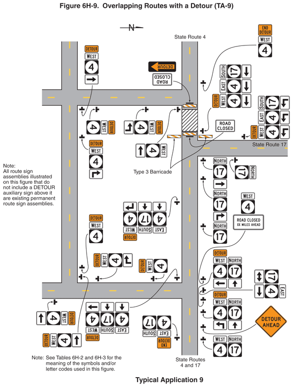
Figure 6H-9. Overlapping Routes with a Detour (TA-9)
This figure illustrates an example of overlapping routes with a detour. A legend under the figure states that this is Typical Application 9. A note states "See Tables 6H-2 and 6H-3 for the meaning of the symbols and/or letter codes used in this figure."
This figure shows two vertical two-lane roadways intersecting three horizontal two-lane roadways. The two lanes on all of the roadways are shown separated by a broken yellow line. The vertical roadway on the right is labeled State Routes 4 and 17 at the bottom of the figure and State Route 4 at the top of figure. A horizontal roadway intersecting the vertical roadway from the right is labeled State Route 17. The two other horizontal roadways are shown intersecting the vertical roadway on the right in a T-shaped intersection, one above the intersecting roadway from the right and one below the intersecting roadway from the right. Both of these roadways then are shown extending to the left side of the figure. The second vertical roadway near the left side of the diagram is shown beginning in an inverted T-shaped intersection with the bottom horizontal roadway and extending to the top of the diagram after intersecting the top horizontal roadway in a four-leg intersection. A note states: "All route sign assemblies illustrated on this figure that do not include a DETOUR auxiliary sign above it are existing permanent route sign assemblies."
At the bottom of the figure and to the right of the right lane of State Routes 4 and 17, a black inverted "T" is shown denoting a sign assembly. The sign assembly is shown with a square black State Route sign with a black numeral "4" on a white disc inscribed within the square, with a horizontal rectangular white cardinal direction marker with the word "WEST" in black above it. These signs are shown to the left of a State Route sign assembly for NORTH 17. Beyond this sign assembly, a diamond-shaped orange sign with a black border is shown with the words "DETOUR AHEAD" in black. Beyond this sign, a sign assembly is shown with a horizontal rectangular orange marker with the word "DETOUR" in black above a WEST 4 State Route sign above a horizontal rectangular white panel with a black right-angle arrow pointing up and to the left. With this sign assembly, a NORTH 17 State Route sign is shown above a horizontal rectangular white sign with a short upward-pointing vertical black arrow. Beyond this sign assembly, another DETOUR WEST 4 State Route sign assembly is shown with a panel with a left-facing horizontal arrow pointing at the intersection with the bottom horizontal roadway. This sign assembly is shown with a NORTH 17 State Route sign above an upward-pointing vertical arrow panel. Just beyond this sign assembly, a sign assembly is shown that faces eastbound traffic on the bottom horizontal roadway. It is shown as a 17 State Route sign above a double-headed horizontal arrow panel and to the left of an EAST 4 State Route sign above a right-pointing arrow panel. Just beyond the intersection with the horizontal roadway, WEST 4 State Route sign assembly is shown with a horizontal rectangular white sign with a black border and the words "ROAD CLOSED XX MILES AHEAD" in black. Beyond this sign, a NORTH 17 State Route sign is shown followed by a NORTH 17 State Route sign assembly above a panel with a right-angle black arrow pointing up and to the right. Beyond this sign, at the intersection with the horizontal roadway labeled State Route 17, a NORTH 17 State Route sign assembly is shown above a right-pointing arrow panel.
State Route 17 joins Route 4 from the right. On the north side of State Route 17, there are three orange and white diagonally striped Type III barricades. One extends across State Route 4 and one is on each of the roadway. Directly behind the barricade, there is square black and white diagonally striped rectangle, denoting a work space, across both lanes. On the north side of the work space, there is another Type III barricade with a sign attached to it facing the southbound traffic. The sign has the message ROAD CLOSED. A DETOUR arrow sign pointing west is mounted below this sign. Beyond the work space on State Route 4, the upper horizontal roadway intersects State Route 4 on the west. Beyond this point on State Route 4, there is an END DETOUR WEST 4 sign assembly facing northbound traffic.
On the left, southbound lane of State Route 4 south of State Route 17, there is a sign assembly on the west side of the roadway. It is composed of an EAST 4 assembly above an arrow pointing straight ahead, a SOUTH 17 assembly above an arrow pointing straight ahead, and a DETOUR WEST 4 assembly above an arrow pointing straight and then 90 degrees to the right. Beyond these signs and at the intersection with the lower horizontal roadway, there are more sign assemblies. There is an EAST 4 straight arrow assembly, a SOUTH 17 straight arrow assembly, and a DETOUR WEST 4 right-pointing arrow assembly. On the south side of the intersection, there is an END DETOUR EAST 4 assembly next to a SOUTH 17 assembly.
On the upper horizontal roadway, east of the leftmost vertical roadway and facing eastbound traffic, there is a DETOUR WEST 4 sign assembly. Beyond this, there is another DETOUR WEST 4 sign assembly mounted above a supplemental arrow plaque with an arrow pointing straight and then 90 degrees to the left. Beyond this, at the intersection with State Route 4, there is another DETOUR WEST 4 sign assembly with an arrow pointing to the left.
At the bottom of the figure, the leftmost vertical roadway intersects the lower horizontal roadway. On the vertical roadway just north of this intersection, there is a DETOUR WEST 4 sign assembly to the right of the roadway facing northbound traffic. Beyond this sign, there is another DETOUR WEST 4 sign above a supplemental plaque with an arrow pointing straight ahead and then 90 degrees to the right. Beyond this sign and at the intersection with the upper horizontal roadway, there is another DETOUR WEST 4 sign assembly with an arrow pointing to the right.
On the lowest horizontal roadway, on the south side of the roadway and just west of the intersection with the leftmost vertical roadway, there is a DETOUR WEST 4 sign assembly above a left-pointing arrow. On the north side of the roadway near State Route 4 and facing westbound traffic, there is a DETOUR WEST 4 sign assembly. Beyond it, there is another DETOUR WEST 4 sign assembly above a supplemental plaque with an arrow pointing straight and then 90 degrees to the right. Beyond this, at the intersection with the leftmost vertical roadway, there is another DETOUR WEST 4 sign above a right-pointing arrow.