
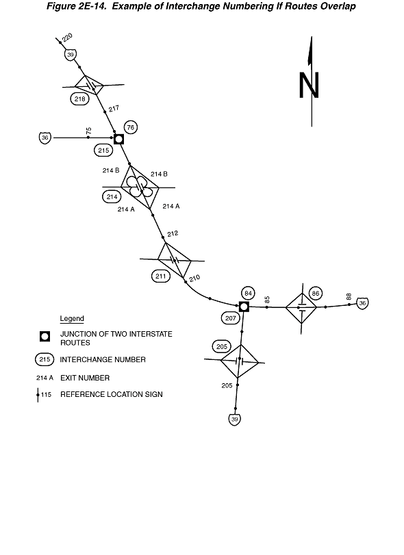
Figure 2E-14. Example of Interchange Numbering If Routes Overlap
This figure shows an example of interchange numbering if routes overlap.
The figure shows a map of two Interstate routes: a vertical highway labeled Interstate 39 intersecting a diagonal highway running east-west. The east portion of the diagonal highway is labeled Interstate 36, and the west portion is labeled both Interstate 36 and 39, with a highway exiting the northern part of the highway to the west and labeled Interstate 36.
At the top right of the figure, a black capital letter "N" is shown superimposed on an upward-pointing vertical black arrow, denoting the compass direction. A legend at the bottom of the figure shows a white disc superimposed on a black square, labeled "JUNCTION OF TWO INTERSTATE ROUTES"; the numerals "215" inside a black oval, labeled "INTERCHANGE NUMBER"; the notation "214A," labeled "EXIT NUMBER"; and a black dot superimposed on a vertical black line next to the numeral "115," labeled "REFERENCE LOCATION SIGN."
On all three routes, black dots denoting reference location signs (some of which are accompanied by numbers and some of which are not) are depicted spaced at intervals along the route, and each of the exits is shown with an interchange number.
This description first lists the Interstate 39 interchanges and then the Interstate 36 interchanges. On both routes, the exits are shown numbered according to the reference location sign exit numbering, rather than consecutively.
At the bottom of the figure, Interstate 39 is shown running north-south. It shows the following interchanges and numbered reference location signs:
- Reference location sign 205
- Interchange 205, a diamond interchange
- Interchange 207, the junction with Interstate 36. It is also interchange 84 on Interstate 36.
On the right side of the figure, Interstate 36 is shown running east-west, overlapping a portion of Interstate 39. From east to west, it shows the following interchanges and numbered reference location signs:
- Reference location sign 88.
- Interchange 86, a diamond interchange
- Reference location sign 85
- Interchange 84, which is the junction with Interstate 39. This is interchange 207 on Interstate 39.
- Reference location sign 210
- Interchange 211, a diamond interchange
- Reference location sign 212
- Interchange 214, a cloverleaf, with Exits 214A and 214B in each direction. In the northbound direction, Exit 214A is shown preceding 214B. In the southbound direction, Exit 214B is shown preceding 214A.
- Interchange 215, which is the junction where Interstate 36 and Interstate 39 split. This is interchange 76 on Interstate 39. On Interstate 36 west of this interchange, reference point 75 is shown.
- Reference location sign 217
- Interchange 218, a diamond interchange
- Reference location sign 220.