
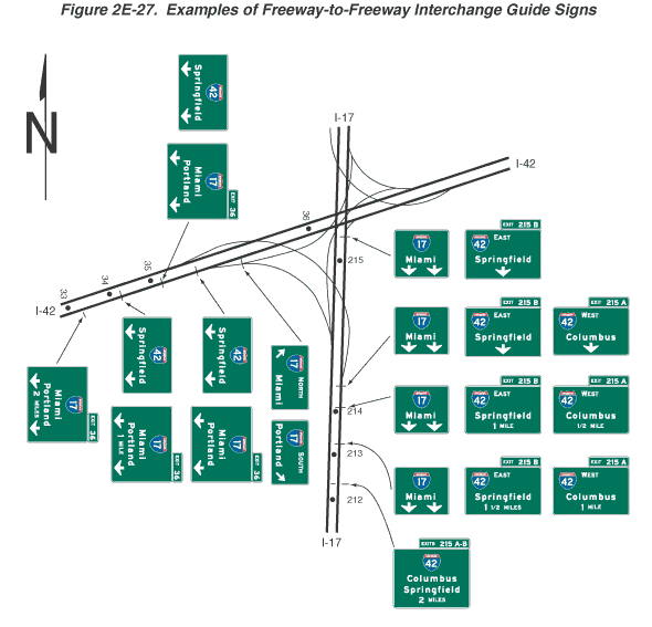
Figure 2E-27. Examples of Freeway-to-Freeway Interchange Guide Signs
This figure shows 21 freeway-to-freeway interchange guide signs.
The figure shows one direction of travel on each of two Interstate highways where they intersect. I-17 is shown vertically, and I-42 is shown horizontally. A series of horizontal rectangular green signs and sign assemblies, all with white lettering and white borders, are shown along the freeways from the bottom to the top of the figure and from the left to the right. All signs display a red and blue Interstate route shield with white numerals. Numbers are shown along both freeways to designate reference location signs every mile. At the top left of the figure, a black capital letter "N" is shown superimposed on an upward-pointing vertical black arrow, denoting the compass direction.
The interchange shown is that of I-17 and I-42. The signs are for the interchange of northbound traffic on I-17 and eastbound traffic on I-42. Off-route movement from both Interstates is to the right. The interchange is shown to be closest to mile 215 on I-17 and closest to mile 36 on I-42.
There are 12 signs or sign assemblies shown on northbound I-17:
- The first sign on northbound I-17 is shown shortly after the reference location sign 212. It is shown to the right of the freeway. The shield for Interstate 42 is shown centered on the top line. Below it, the word "Columbus" is shown on the second line, the word "Springfield" is shown on the third line, and the words "2 MILES" are shown on the fourth line. A smaller horizontal rectangular green plaque is shown above the top right side of the sign. It shows the words "EXIT 215 A-B."
- The second, third, and fourth signs on I-17 are shown shortly after the reference location sign 213. They are shown as a sign assembly in a horizontal array and located over the right lane. On the sign on the left, the shield for Interstate 17 is shown centered on the top line. Below it, the word "Miami" is shown on the middle line above two vertical white downward-pointing arrows with short shafts on the bottom line. On the sign in the middle, the shield for Interstate 42 is shown to the left of the word "EAST" on the top line. Below it, the word "Springfield" is shown on the middle line, and the words "1 ½ MILES" are shown on the bottom line. A smaller horizontal rectangular green plaque is shown above the top right side of the sign. It shows the words "EXIT 215 B." On the sign on the right, the shield for Interstate 42 is shown to the left of the word "WEST" on the top line. Below it, the word "Columbus" is shown on the middle line, and the words "1 MILE" are shown on the bottom line. A smaller horizontal rectangular green plaque is shown above the top right side of the sign. It shows the words "EXIT 215 A."
- The fifth, sixth, and seventh signs on I-17 are shown shortly after the reference location sign 214. They are shown as a sign assembly located and shown as identical to the second, third, and fourth signs, except the words "1 MILE" are shown below the word "Springfield" instead of the words "1 ½ MILES" on the middle sign, and the word "1/2 MILE" is shown below the word "Columbus" instead of the words "1 MILE" on the sign on the right.
- The eighth, ninth, and 10th signs on I-17 are shown just in advance of where a right exit for I-42 is shown crossing over I-17 to the left. The signs are shown as a sign assembly identical to the fifth, sixth, and seventh signs, except the words "1 MILE" under the word "Springfield" on the middle sign and the words "1/2 MILE" under the word "Columbus" on the right sign are each replaced by a vertical downward-pointing arrow with a short shaft.
- The 11th and 12th signs on I-17 are shown just beyond reference location sign 215 and in advance of where an exit is shown curving to the right to I-42. The signs are shown as a sign assembly identical to the eighth and ninth signs, but no third sign, for Interstate 42 West, is shown.
There are nine signs or sign assemblies shown on eastbound I-42:
- The first sign on eastbound I-42 is shown shortly after the reference location sign 33. It is shown to the right of the freeway. The shield for Interstate 17 is shown centered on the top line. Below it, the word "Miami" is shown on the second line, the word "Portland" on the third line, and the words "2 MILES" on the fourth line. A smaller horizontal rectangular green plaque is shown above the top right side of the sign. It shows the words "EXIT 36."
- The second and third signs on eastbound I-42 are shown shortly after the reference location sign 34. They are shown as a sign assembly in a horizontal array and located over the right lane. On the sign on the left, the shield for Interstate 42 is shown centered on the top line. Below it, the word "Springfield" is shown on the middle line above two vertical white downward-pointing arrows with short shafts on the bottom line. On the sign on the right, the shield for Interstate 17 is shown centered on the top line. Below it, the word "Miami" is shown on the second line, the word "Portland" on the third line, and the words "1 MILE" on the fourth line centered between two vertical white downward-pointing arrows with short shafts. A smaller horizontal rectangular green plaque is shown above the top right side of the sign. It shows the words "EXIT 36."
- The fourth and fifth signs on eastbound I-42 are shown shortly after the reference location sign 35. They are shown as a sign assembly located and shown as identical to the second and third signs, except the words "1 MILE" are not shown below the word "Portland" on the sign on the right.
- The sixth and seventh signs on eastbound I-42 are shown shortly after the fourth and fifth signs. They are shown as a sign assembly located and shown as identical to the fourth and fifth signs.
- The eighth and ninth signs on eastbound I-42 are shown where an exit is shown curving to the right to I-17. They are shown as a sign assembly in a horizontal array and located over the exit lane. On the sign on the left, the shield for Interstate 17 is shown to the left of the word "NORTH" on the top line, and a diagonal arrow pointing up and to the left is shown to the left of the word "Miami" on the bottom line. On the sign on the right, the shield for Interstate 17 is shown to the left of the word "SOUTH" on the top line, and the word "Portland" to the left of a diagonal arrow pointing up and to the right on the bottom line.
- The reference location sign 36 is shown farther along the freeway, in advance of the I-17 crossover.