
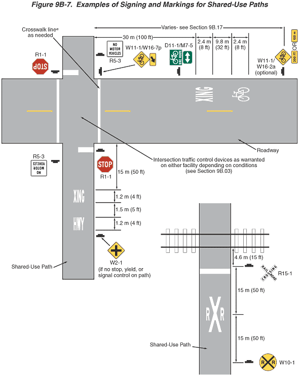
Figure 9B-7. Examples of Signing and Markings for Shared-Use Paths
This figure illustrates two examples of signing and markings for shared-use paths.
The first example shows an intersection of a horizontal roadway and a vertical shared-use path. The roadway is shown as composed of two lanes separated by a broken yellow line. A note states: "Intersection traffic control devices as warranted on either facility depending on conditions (see Section 9B.03)."
At the bottom of the bottom half of the vertical shared-use path in advance of the intersection, a W2-1 diamond-shaped yellow sign with a cross is shown to the right of the roadway facing northbound path traffic and noted as "if no stop, yield, or sign control on path." Just beyond it, the word "HWY" in advance of the word "XING" are shown marked in white centered on the path pavement. Each word is shown as a dimension of 1.2 m (4 ft) high with a dimension of 1.5 m (5 ft) between the two words. The far edge of the word "XING" is shown as a dimensioned distance of 15 m (50 ft) in advance of the intersection with the horizontal roadway. An R1-1 Stop sign is shown facing northbound path traffic at the intersection with the roadway. Adjacent to the R1-1 Stop sign, a white stop line is shown extending across the right half of the shared-use path. Opposite the Stop sign and on the other side of the path facing southbound path traffic, an R5-3 sign is shown with the words "NO MOTOR VEHICLES" on three lines.
On the top part of the vertical path in advance of the intersection, an R1-1 Stop sign is shown to the right side of the path, facing southbound path traffic. Adjacent to the Stop sign, a white stop line is shown extending across the right half of the path. On the other side of the path, just north of the intersection and facing northbound path traffic, another R5-3 sign is shown with the words "NO MOTOR VEHICLES" on three lines.
On the horizontal roadway, solid white lines are shown marked on each side of the roadway intersection with the path and parallel to the path. A note with an arrow pointing to one of these white lines states: "Crosswalk lines as needed." Facing westbound traffic on the roadway, a sign assembly is shown to the right of the roadway at the northwest corner of the intersection. The assembly is shown as composed of a W11-1 bicycle symbol sign mounted above a W16-7p plaque with a diagonal arrow pointing down and to the left. Farther to the right on the figure and in advance of this sign assembly, a sign assembly is shown to the right of the roadway, facing westbound traffic. It is shown as composed of a D11-1 Bike Route sign mounted above an M7-5 plaque with a two-direction horizontal arrow. The word "XING" is shown marked in white on the westbound lane. The westernmost edge of the word "XING" is shown as a dimensioned distance of 30 m (100 ft) in advance of the intersection. Farther east, a white symbol of a bicycle is shown marked on the westbound lane. The heights of the bicycle symbol and the word "XING" are both shown as a dimension of 2.4 m (8 ft), and the distance between the symbol and the word is shown as a dimension of 9.8 m (32 ft). Farther to the right on the roadway and in advance of the pavement markings, a sign assembly is shown to the right of the roadway facing westbound traffic and is labeled "optional." The sign assembly is shown composed of a W11-1 bicycle symbol sign and a W16-2a plaque with the words "300 FT" or the metric equivalent sign with the words "100 m." A note states that the distance from this sign assembly to the intersection "Varies—see Section 9B.17."
The second example shows a vertical shared-use path intersecting a horizontal railroad track. An R15-1 Railroad Crossing crossbuck sign is shown to the right of the path, facing northbound path traffic. It is shown adjacent to a solid white line that extends across the entire path. The R15-1 crossbuck and solid white line are shown as a dimensioned distance of 4.6 m (15 ft) in advance of the near edge of the railroad track. A white "X" with smaller white letter "R’s" on each side of the "X" are shown marked and centered on the path pavement. The center of the "X" is shown as a dimensioned distance of 15 m (50 ft) south of the R15-1 sign. At the bottom of the path, a W10-1 round sign with an "X" and smaller letter "R's" on each side is shown to the right of the path, facing northbound path traffic. The W10-1 sign is shown as a dimensioned distance of 15 m (50 ft) in advance of the center of the "X" marking.