
Chapter 3B. Pavement and Curb Markings
Section 3B.16 Stop and Yield Lines
Standard:
If used, stop lines shall consist of solid white lines extending
across approach lanes to indicate the point at which the stop is
intended or required to be made.
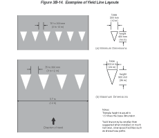
If used, yield lines (see Figure 3B-14) shall consist of a row of solid white isosceles triangles pointing toward approaching vehicles extending across approach lanes to indicate the point at which the yield is intended or required to be made.
Figure 3B-14 Examples of Yield Line Layouts
Guidance:
Stop lines should be 300 to 600 mm (12 to 24 in) wide.
Stop lines should be used to indicate the point behind which vehicles are required to stop, in compliance with a STOP (R1-1) sign, traffic control signal, or some other traffic control device, except YIELD signs.
The individual triangles comprising the yield line should have a base of 300 to 600 mm (12 to 24 in) wide and a height equal to 1.5 times the base. The space between the triangles should be 75 to 300 mm (3 to 12 in).
Option:
Yield lines may be used to indicate the point behind which vehicles
are required to yield in compliance with a YIELD (R1-2) sign or
a Yield Here to Pedestrians (R1-5 or R1-5a) sign.
Guidance:
If used, stop and yield lines should be placed a minimum of 1.2
m (4 ft) in advance of the nearest crosswalk line at controlled
intersections, except for yield lines at roundabout intersections
as provided for in Section 3B.24 and
at midblock crosswalks. In the absence of a marked crosswalk, the
stop line or yield line should be placed at the desired stopping
or yielding point, but should be placed no more than 9 m (30 ft)
nor less than 1.2 m (4 ft) from the nearest edge of the intersecting
traveled way. Stop lines should be placed to allow sufficient sight
distance to all other approaches to an intersection.
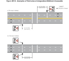
If used at an unsignalized midblock crosswalk, yield lines should be placed adjacent to the Yield Here to Pedestrians sign located 6.1 to 15 m (20 to 50 ft) in advance of the nearest crosswalk line, and parking should be prohibited in the area between the yield line and the crosswalk (see Figure 3B-15).
Figure 3B-15 Examples of Yield Lines at Unsignalized Midblock Crosswalks
Stop lines at midblock signalized locations should be placed at least 12 m (40 ft) in advance of the nearest signal indication (see Section 4D.15).
Support:
Drivers who yield too close to crosswalks on multi-lane approaches
place pedestrians at risk by blocking other drivers' views of pedestrians.
Section 3B.17 Crosswalk Markings
Support:
Crosswalk markings provide guidance for pedestrians who are crossing
roadways by defining and delineating paths on approaches to and
within signalized intersections, and on approaches to other intersections
where traffic stops.
Crosswalk markings also serve to alert road users of a pedestrian crossing point across roadways not controlled by highway traffic signals or STOP signs.
At nonintersection locations, crosswalk markings legally establish the crosswalk.
Standard:
When crosswalk lines are used, they shall consist of solid white
lines that mark the crosswalk. They shall be not less than 150 mm
(6 in) nor greater than 600 mm (24 in) in width.
Guidance:
If transverse lines are used to mark a crosswalk, the gap between
the lines should not be less than 1.8 m (6 ft). If diagonal or longitudinal
lines are used without transverse lines to mark a crosswalk, the
crosswalk should not be less than 1.8 m (6 ft) wide.
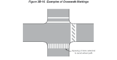
Crosswalk lines, if used on both sides of the crosswalk, should extend across the full width of pavement or to the edge of the intersecting crosswalk to discourage diagonal walking between crosswalks (see Figures 3B-15 and 3B-16).
Figure 3B-16 Examples of Crosswalk Markings
Crosswalks should be marked at all intersections where there is substantial conflict between vehicular and pedestrian movements.
Marked crosswalks also should be provided at other appropriate points of pedestrian concentration, such as at loading islands, midblock pedestrian crossings, or where pedestrians could not otherwise recognize the proper place to cross.
Crosswalk lines should not be used indiscriminately. An engineering study should be performed before they are installed at locations away from highway traffic signals or STOP signs.
Because nonintersection pedestrian crossings are generally unexpected by the road user, warning signs (see Section 2C.41) should be installed and adequate visibility should be provided by parking prohibitions.
Support:
Section 3B.16 contains information regarding
placement of stop line markings near crosswalk markings.
Option:
For added visibility, the area of the crosswalk may be marked with
white diagonal lines at a 45-degree angle to the line of the crosswalk
or with white longitudinal lines parallel to traffic flow as shown
in Figure 3B-16.
When diagonal or longitudinal lines are used to mark a crosswalk, the transverse crosswalk lines may be omitted. This type of marking may be used at locations where substantial numbers of pedestrians cross without any other traffic control device, at locations where physical conditions are such that added visibility of the crosswalk is desired, or at places where a pedestrian crosswalk might not be expected.
Guidance:
If used, the diagonal or longitudinal lines should be 300 to 600
mm (12 to 24 in) wide and spaced 300 to 1500 mm (12 to 60 in) apart.
The marking design should avoid the wheel paths, and the spacing
should not exceed 2.5 times the line width.
Option:
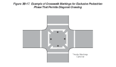
When an exclusive pedestrian phase that permits diagonal crossing
is provided at a traffic control signal, a marking as shown in Figure
3B-17 may be used for the crosswalk.
Figure 3B-17 Example of Crosswalk Markings for Exclusive Pedestrian Phase That Permits Diagonal Crossing
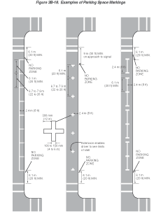
Section 3B.18 Parking Space Markings
Support:
Marking of parking space boundaries encourages more orderly and
efficient use of parking spaces where parking turnover is substantial.
Parking space markings tend to prevent encroachment into fire hydrant
zones, bus stops, loading zones, approaches to intersections, curb
ramps, and clearance spaces for islands and other zones where parking
is restricted. Examples of parking space markings are shown in Figure
3B-18.
Figure 3B-18 Examples of Parking Space Markings
Standard:
Parking space markings shall be white.
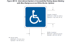
Option:
Blue lines may supplement white parking space markings of each parking
space designated for use only by persons with disabilities.
Support:
Additional parking space markings for the purpose of designating
spaces for use only by persons with disabilities are discussed in
Section 3B.19 and illustrated in Figure 3B-19.
Figure 3B-19 International Symbol of Accessibility Parking Space Marking with Blue Background and White Border Options
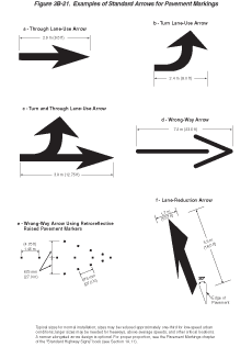
Section 3B.19 Pavement Word and Symbol Markings
Support:
Word and symbol markings on the pavement are used for the purpose
of guiding, warning, or regulating traffic. Symbol messages are
preferable to word messages. Examples of standard word and arrow
pavement markings are shown in Figures 3B-20 and 3B-21.
Figure 3B-20 Example of Elongated Letters for Word Pavement Markings

Figure 3B-21 Examples of Standard Arrows for Pavement Markings
Standard:
Word and symbol markings shall be white, except as otherwise noted
in this Section.
Guidance:
Letters and numerals should be 1.8 m (6 ft) or more in height.
Word and symbol markings should not exceed three lines of information.
If a pavement marking word message consists of more than one line of information, it should read in the direction of travel. The first word of the message should be nearest to the road user.
Except for the two opposing arrows of a two-way left-turn lane marking, (see Figure 3B-7), the longitudinal space between word or symbol message markings, including arrow markings, should be at least four times the height of the characters for low-speed roads, but not more than ten times the height of the characters under any conditions.
The number of different word and symbol markings used should be minimized to provide effective guidance and avoid misunderstanding.
Except as noted in the Option, pavement word and symbol markings should be no more than one lane in width.
Option:
The SCHOOL word marking may extend to the width of two approach
lanes (see Section 7C.06).
Guidance:
When the SCHOOL word marking is extended to the width of two approach
lanes, the characters should be 3m (10 ft) or more in height (see
Section 7C.06).
Pavement word and symbol markings should be proportionally scaled to fit within the width of the facility upon which they are applied.
Option:
On narrow, low-speed shared-use paths, the pavement words and symbols
may be smaller than suggested, but to the relative scale.
The International Symbol of Accessibility parking space markings may be placed in each parking space designated for use by persons with disabilities. A blue background with white border may supplement the wheelchair symbol as shown in Figure 3B-19.
Standard:
Where through traffic lanes approaching an intersection become mandatory
turn lanes, lane-use arrow markings (see Figure
3B-21) shall be used and shall be accompanied by standard signs.
Lane use, lane reduction, and wrong-way arrow markings shall be designed as shown in Figure 3B-21.
Guidance:
Where through lanes become mandatory turn lanes, signs or markings
should be repeated as necessary to prevent entrapment and to help
the road user select the appropriate lane in advance of reaching
a queue of waiting vehicles.
Option:
Lane-use arrow markings (see Figure 3B-21) may be used to convey
either guidance or mandatory messages.
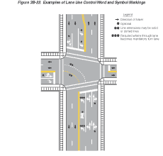
The ONLY word marking (see Figure 3B-20) may be used to supplement lane-use arrow markings (see Figure 3B-22).
Figure 3B-22 Examples of Lane Use Control Word and Symbol Markings
In situations where a lane reduction transition occurs, the lane reduction arrow markings shown in Figure 3B-21 may be used.
Guidance:
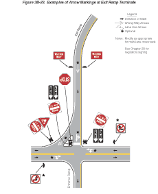
Where crossroad channelization or ramp geometrics do not make wrong-way
movements difficult, a lane-use arrow should be placed in each lane
of an exit ramp near the crossroad terminal where it will be clearly
visible to a potential wrong-way road user (see Figure 3B-23).
Figure 3B-23 Examples of Arrow Markings at Exit Ramp Terminals
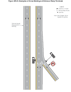
Option:
The wrong-way arrow markings shown in Figure 3B-21 may be placed
near the downstream terminus of a ramp as shown in Figures 3B-23
and 3B-24 to indicate the correct direction of traffic flow and
to discourage drivers from traveling in the wrong direction.
Figure 3B-24 Examples of Arrow Markings at Entrance Ramp Terminals
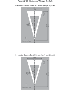
A yield-ahead triangle symbol or YIELD AHEAD word pavement marking may be used on approaches to intersections where the approaching traffic will encounter a YIELD sign at the intersection (see Figure 3B-25).
Figure 3B-25 Yield Ahead Triangle Symbols
Support:
Lane-use arrow markings are often used to provide guidance in turn
bays (see Figure 3B-22), where turns may
or may not be mandatory, and in two-way left-turn lanes (see Figure
3B-7).
Option:
Word and symbol markings may include, but are not limited to, the
following. Other words or symbols may also be used under certain
conditions.
- Regulatory:
- STOP
- RIGHT (LEFT) TURN ONLY
- 40 km/h (25 MPH)
- Arrow Symbols
- Warning:
- STOP AHEAD
- YIELD AHEAD
- YIELD AHEAD Triangle Symbol
- SCHOOL XING
- SIGNAL AHEAD
- PED XING
- SCHOOL
- R X R
- BUMP
- HUMP
- Guide:
- US 40
- STATE 135
- ROUTE 40
Standard:
Except at the ends of aisles in parking lots, the word STOP shall
not be used on the pavement unless accompanied by a stop line (see
Section 3B.16) and STOP sign (see Section
2B.04). At the ends of aisles in parking lots, the word STOP
shall not be used on the pavement unless accompanied by a stop line.
The word STOP shall not be placed on the pavement in advance of a stop line, unless every vehicle is required to stop at all times.
The yield-ahead triangle symbol or YIELD AHEAD word pavement marking shall not be used unless a YIELD sign (see Section 2B.08) is in place at the intersection. The yield-ahead symbol marking shall be as shown in Figure 3B-25.
Section 3B.20 Speed Measurement Markings
Support:
A speed measurement marking is a transverse marking placed on the
roadway to assist the enforcement of speed regulations.
Standard:
Speed measurement markings, if used, shall be white, and shall not
be greater than 600 mm (24 in) in width.
Option:
Speed measurement markings may extend 600 mm (24 in) on either side
of the centerline or 600 mm (24 in) on either side of edge line
markings at 400 m (0.25 mi) intervals over a 1.6 km (1 mi) length
of roadway. When paved shoulders of sufficient width are available,
the speed measurements markings may be placed entirely on these
shoulders. Advisory signs may be used in conjunction with these
markings (see Figure 3B-10).
Section 3B.21 Curb Markings
Support:
Curb markings are most often used to indicate parking regulations
or to delineate the curb.
Standard:
Signs shall be used with curb markings in those areas where curb
markings are frequently obliterated by snow and ice accumulation
unless the no parking zone is controlled by statute or local ordinance.
Where curbs are marked, the colors shall conform to the general principles of markings (see Section 3A.04).
Guidance:
Except as noted in the Option, when curb markings are used without
signs to convey parking regulations, a legible word marking regarding
the regulation (such as "No Parking" or "No Standing")
should be placed on the curb.
Option:
Curb markings without word markings or signs may be used to convey
a general prohibition by statute of parking within a specific distance
of a STOP sign, driveway, fire hydrant, or crosswalk.
Guidance:
Retroreflective solid yellow markings should be placed on the noses
of raised medians and curbs of islands that are located in the line
of traffic flow where the curb serves to channel traffic to the
right of the obstruction.
Retroreflective solid white markings should be used when traffic may pass on either side of the island.
Option:
Local highway agencies may prescribe special colors for curb markings
to supplement standard signs for parking regulation.
Support:
Since yellow and white curb markings are frequently used for curb
delineation and visibility, it is advisable to establish parking
regulations through the installation of standard signs (see Sections
2B.39
through 2B.41).
Where the curbs of the islands become parallel to the direction of traffic flow, it is not necessary to mark the curbs unless an engineering study indicates the need for this type of delineation.
Curbs at openings in a continuous median island need not be marked unless an engineering study indicates the need for this type of marking.
Section 3B.22 Preferential Lane Word and Symbol Markings
Standard:
When a lane is assigned full or part time to a particular class
or classes of vehicles, preferential lane markings shall be used.
Signs or signals shall be used with preferential lane word or symbol markings.
All preferential lane word and symbol markings shall be white.
All preferential lane word and symbol markings shall be positioned laterally in the center of the preferred-use lane.
Support:
Preferential lanes identify a wide variety of special uses, including,
but not limited to, high-occupancy vehicle (HOV) lanes, bicycle
lanes, bus only lanes, taxi only lanes, and light rail transit only.
Standard:
Where a preferential lane use is established, the preferential lane
shall be marked with one or more of the following symbol or word
markings for the preferential lane use specified:
- HOV lane—the preferential lane use marking for high-occupancy vehicle lanes shall consist of white lines formed in a diamond shape symbol or the word message HOV. The diamond shall be at least 0.75 m (2.5 ft) wide and 3.7 m (12 ft) in length. The lines shall be at least 150 mm (6 in) in width.
- Bicycle lane—the preferential lane use marking for a bicycle lane shall consist of a bicycle symbol or the word marking BIKE LANE (see Chapter 9C and Figures 9C-1 and 9C-3 through 9C-6).
- Bus only lane—the preferential lane use marking for a bus only lane shall consist of the word marking BUS ONLY.
- Taxi only lane—the preferential lane use marking for a taxi only lane shall consist of the word marking TAXI ONLY.
- Light rail transit lane—the preferential lane use marking for a light rail transit lane shall consist of the letter T.
- Other preferential lane use markings shall be identified in accordance with Section 3B.23.
If two or more preferential lane uses are permitted in a single lane, the symbol or word marking for each preferential lane use shall be installed.
Guidance:
Engineering judgment should determine the need for supplemental
devices such as tubular markers, traffic cones, or flashing lights.
Support:
The spacing of the markings is an engineering judgment that is based
on the prevailing speed, block lengths, distance from intersections,
and other factors that affect clear communication to the road user.
Markings spaced as close as 24 m (80 ft) apart might be appropriate
on City streets, while markings spaced 300 m (1,000 ft) might be
appropriate for freeways.
Option:
The vehicle occupancy requirements established for a high-occupancy
vehicle lane may be included in sequence after the diamond symbol
or HOV word message.
Section 3B.23 Preferential Lane Longitudinal Markings for Motor Vehicles
Standard:
Preferential lane longitudinal markings for motor vehicles shall
be marked with the appropriate word or symbol pavement markings
in accordance with Section 3B.22.
Support:
Preferential lanes can take many forms depending on the level of
usage and the design of the facility. They might be physically separated
from the other travel lanes by a barrier, median, or painted neutral
area, or they might be concurrent with other travel lanes and be
separated only by longitudinal pavement markings. Further, physically
separated preferential lanes might operate in the same direction
or be reversible.
Option:
Preferential lanes may be operated either full-time (24 hours per
day on all days), for extended periods of the day, or part-time
(restricted usage during specific hours on specified days).
Standard:
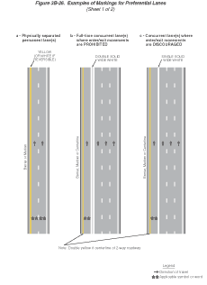
The following four items are presented in tabular form in Table
3B-2:
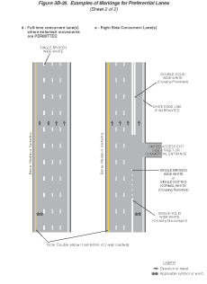
- Physically separated, nonreversible preferential lane—the longitudinal pavement markings for preferential lanes that are physically separated from the other travel lanes by a barrier, median, or painted neutral area shall consist of a single normal solid yellow line at the left edge of the travel lane(s), a single normal solid white line at the right edge of the travel lane(s), and if there are two or more preferential lanes, the preferential travel lanes shall be separated with a normal broken white line (see Figure 3B-26a).
- Physically separated, reversible preferential lane—the longitudinal pavement markings for reversible preferential lanes that are physically separated from the other travel lanes by a barrier, median, or painted neutral area shall consist of a single normal solid white line at both edges of the travel lane(s), and if there are two or more preferential lanes, the preferential travel lanes shall be separated with a normal broken white line (see Figure 3B-26a).
- Concurrent flow (left side) preferential lane—the longitudinal
pavement markings for a full-time or part-time preferential
lane on the left side of the other traveled lanes shall consist
of a single normal solid yellow line at the left edge of the
preferential travel lane(s) and one of the following at the
right edge of the preferential travel lane(s):
- A double solid wide white line where crossing is prohibited (see Figure 3B-26b).
- A single solid wide white line where crossing is discouraged (see Figure 3B-26c).
- A single broken wide white line where crossing is permitted (see Figure 3B-26d).
If there are two or more preferential lanes, the preferential travel lanes shall be separated with a normal broken white line.
- Concurrent flow (right side) preferential lane—the longitudinal
pavement markings for a full-time or part-time preferential
lane on the right of the other travel lanes shall consist of
a single normal solid white line at the right edge of the preferential
travel lane(s) if warranted and one of the following at the
left edge of the preferential travel lane(s):
- A double solid wide white line where crossing is prohibited (see Figure 3B-26b).
- A single solid wide white line where crossing is discouraged (see Figure 3B-26c).
- A single broken wide white line where crossing is permitted (see Figure 3B-26d).
- A single dotted normal white line where crossing is permitted for any vehicle to perform a right turn maneuver (see Figure 3B-26e).
If there are two or more preferential lanes, the preferential travel lanes shall be separated with a normal broken white line.
| Type of Preferential Lane | Left Edge Line | Right Edge Line |
|---|---|---|
| Physically Separated, Nonreversible | A single normal solid yellow line | A single normal solid white line |
| Physically Separated, Reversible | A single normal solid white line | A single normal solid white line |
| Concurrent Flow— Left Side | A single normal solid yellow line | A double solid wide white line
where crossing is prohibited (see Figure
3B-26b)
A single solid wide white line where crossing is discouraged (see Figure 3B-26c) A single broken wide white line where crossing is permitted (see Figure 3B-26d) |
| Concurrent Flow— Right Side | A double solid wide white line
where crossing is prohibited (see Figure
3B-26e)
A single solid wide white line where crossing is discouraged (see Figure 3B-26e) A single broken wide white line where crossing is permitted (see Figure 3B-26e) A single dotted normal white line where crossing is permitted for any vehicle to perform a right-turn maneuver (see Figure 3B-26e) |
A single normal solid white line |
If there are two or more preferential lanes, they shall be separated with a normal broken white line.
The standard lane markings listed in this table are provided in a tabular format for reference.
This information is also described in the second Standard in Section 3B.23.
Figure 3B-26 Examples of Markings for Preferential Lanes (2 Sheets)
Guidance:
When concurrent flow preferential lanes and other travel lanes are
separated by more than 1.2 m (4 ft), chevron markings should be
placed in the neutral area. The chevron spacing should be 30 m (100
ft) or greater.
Option:
For full-time or part-time concurrent flow preferential lanes, the
spacing or skip pattern of the single broken wide white line may
be reduced. The width of the single broken wide white line may be
increased.
Section 3B.24 Markings for Roundabout Intersections
Support:
Roundabout intersections are distinctive circular roadways that
have the following three critical characteristics:
- A requirement to yield at entry which gives a vehicle on the circular roadway the right-of-way;
- A deflection of the approaching vehicle around the central island; and
- A flare or widening of the approach to allow for proper operation as needed.
Examples of markings for roundabout intersections are shown in Figures 3B-27 and 3B-28.
Figure 3B-27 Examples of Markings for Roundabout Intersections with One-Lane Approaches
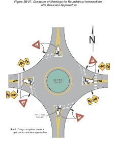
Figure 3B-28 Examples of Markings for Roundabout Intersections with Two-Lane Approaches
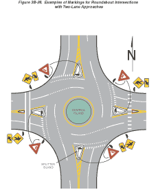
Option:
A yellow edge line may be placed around the inner (left) edge of
the circular roadway.
Guidance:
A white line should be used on the outer (right) side of the circular
roadway as follows: a solid line along the splitter island and a
dotted line across the lane(s) entering the roundabout intersection.
Edge line extensions should not be placed across the exits from the circular roadway.
Where crosswalk markings are used, these markings should be located a minimum of 7.6 m (25 ft) upstream from the yield line, or, if none, from the dotted white line.
Option:
Lane lines may be used on the circular roadway if there is more
than one lane.
A yield line (see Section 3B.16) may be used to indicate the point behind which vehicles are required to yield at the entrance to a roundabout intersection.
Standard:
Bicycle lane markings shall not be provided on the circular roadway
of a roundabout intersection.
Section 3B.25 Markings for Other Circular Intersections
Support:
Other circular intersections include but are not limited to rotaries,
traffic circles, and residential traffic calming designs.
Option:
The markings shown in Figures 3B-27 and 3B-28 may be used at other
circular intersections when engineering judgment indicates that
their presence will benefit drivers or pedestrians.
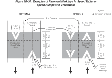
Section 3B.26 Speed Hump Markings
Standard:
If used, speed hump markings shall be a series of white markings
placed on a speed hump to identify its location.
Option:
Speed humps, except those used for crosswalks, may be marked in
accordance with Figure 3B-29. The markings shown in Figure 3B-30
may be used where the speed hump also functions as a crosswalk or
speed table.
Figure 3B-29 Examples of Pavement Markings for Speed Humps Without Crosswalks
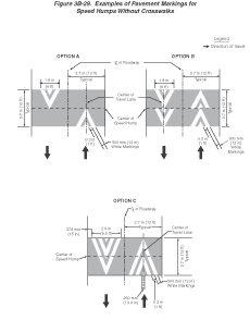
Figure 3B-30 Examples of Pavement Markings for Speed Tables or Speed Humps with Crosswalks
Section 3B.27 Advance Speed Hump Markings
Standard:
If used, advance speed hump markings shall be a special white marking
placed in advance of speed humps or other engineered vertical roadway
deflections such as dips.
Option:
Advance speed hump markings may be used in advance of an engineered
vertical roadway deflection where added visibility is desired or
where such deflection is not expected (see Figure 3B-31).
Figure 3B-31 Examples of Advance Warning Markings for Speed Humps
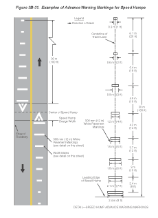
Advance pavement wording such as BUMP or HUMP (see Section 3B.19) may be used on the approach to a speed hump either alone or in conjunction with advance speed hump markings. Appropriate advance warning signs may be used in conformance with Section 2C.24.
Guidance:
If used, advance speed hump markings should be installed in each
approach lane.