|
|
 |
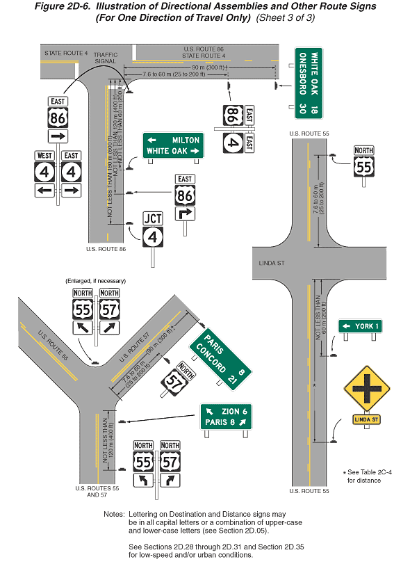
Figure 2D-6. Illustration of Directional Assemblies and Other Route
Signs (For One Direction of Travel Only) (Sheet 3 of 3)
- Sheet 3 of the figure shows three highway intersections. Notes
state "Lettering on Destination and Distance signs may be
in all capital letters or a combination of upper-case and lower-case
letters (see Section 2D.05)."
and "See Sections 2D.28
through 2D.31
and Section 2D.35 for low-speed
and/or urban conditions."
- At the top left side of the sheet, a highway is shown running
vertically labeled "U.S. ROUTE 86" and intersecting
with a T intersection a highway running horizontally labeled
"STATE ROUTE 4" to the left and "U.S. ROUTE 86"
and "STATE ROUTE 4" to the right. The words "TRAFFIC
SIGNAL" are shown in the middle of the intersection. This
figure shows the vertical and horizontal two-lane roadways with
one lane of traffic in each direction. Near the intersection,
the opposing lanes are shown separated by a solid double yellow
line. Farther away from the intersection, the opposing lanes
in each direction are shown separated from each other by a broken
yellow line. Solid white stop lines are shown across the approach
lane on each side of the intersection. The direction of travel
is from the bottom to the top of the figure and then to the
right. There are six sign assemblies shown on the vertical and
horizontal highways, all shown on the right side of the highways:
- At the bottom of the figure a white horizontal rectangular
white sign with the word "JCT" in black is mounted
above a square black state route sign with the numeral "4"
in black. The distance from the near side of the intersection
to this sign is shown as a dimension of not less than 180
m (600 ft).
- Further up the page, a sign assembly is shown with a horizontal
rectangular white sign with the word "EAST" in black
mounted above a square black U.S. Route marker with the number
"86" in black mounted above a horizontal rectangular
white sign with a black arrow at a 90-degree angle pointing
up and to the right. The distance from the near side of the
intersection to this sign is shown as a dimension of not less
than 120 m (400 ft). Farther up the page, a horizontal rectangular
green sign is shown with a left-pointing horizontal white
arrow to the left of the word "MILTON" in white
on the top line and the words "WHITE OAK" in white
to the left of a right-pointing horizontal white arrow on
the bottom line. The distance from the near side of the intersection
to this sign is shown as a dimension of not less than 60 m
(200 ft).
- Just prior to the intersection, at the start of the corner
radius, a sign assembly is shown composed of one assembly
mounted above two others. On top, a horizontal rectangular
white sign with the word "EAST" in black is mounted
above a square black U.S. Route marker with the numeral "86"
in black mounted above horizontal rectangular white sign with
a right-pointing horizontal black arrow. Below this assembly
are two signs. On the left, a horizontal rectangular white
sign is shown with the word "WEST" in black mounted
above a square black state route sign with the numeral "4"
mounted above a horizontal rectangular white sign with a left-pointing
horizontal black arrow. On the right, the same sign assembly
is shown but substituting the word "EAST" and a
right-pointing horizontal arrow.
- On the right side of the horizontal highway, a sign assembly
is shown composed of a horizontal rectangular white sign with
the word "EAST" in black mounted above a square
black U.S. Route marker with the number "86" in
black. These signs are shown mounted to the left of a horizontal
rectangular white sign with the word "EAST" in black
mounted above a square black state route sign with the number
"4" in black. The distance from the near side of
the intersection to this sign assembly is shown as a dimension
of 7.6 to 60 m (25 to 200 ft).
- Farther to the right, a horizontal rectangular green sign
is shown with the words "WHITE OAK" in white to
the left of the numeral "18" in white on the top
line and the word "ONESBORO" in white to the left
of the distance "30" in white on the bottom line.
The distance from the near side of the intersection to this
sign is shown as a dimension of not less than 90 m (800 ft).
- At the bottom left side of the sheet, a highway is shown running
vertically labeled "U.S. ROUTES 55 AND 57" intersecting
two highways at a "Y" intersection labeled "U.S.
ROUTE 55" as the left fork and "U.S. ROUTE 57"
as the right fork. This figure shows the vertical and horizontal
two-lane roadways with one lane of traffic in each direction.
Near the intersection, the opposing lanes are shown separated
by a solid double yellow line. Farther away from the intersection
on the vertical roadway, the opposing lanes in each direction
are shown separated from each other by a broken yellow line.
Solid white stop lines are shown across the approach lanes at
the intersection on the vertical roadway. The direction of travel
is from the bottom to the top of the figure. There are five
sign assemblies shown on these highways, most to the right side
of the highways:
- At the bottom of the figure and to the right of the vertical
highway, a sign assembly is shown composed of a horizontal
rectangular white sign with the word "NORTH" in
black mounted above a square black U.S. Route marker with
the numeral "55" in black above a horizontal rectangular
white sign with a vertical black arrow curving up and to the
left. To its right, the same sign assembly is shown substituting
"57" and an arrow curving to the right. The distance
from the near side of the fork in the highway to this sign
assembly is shown as a dimension of not less than 120 m (400
ft).
- Just prior to the junction of the forks and to the right
of the vertical highway, a horizontal rectangular green sign
is shown with a diagonal white arrow pointing up and to the
left to the left of the word "ZION" and the numeral
"6" in white on the top line. The word "PARIS"
to the left of the numeral "8" in white and a diagonal
white arrow pointing up and to the right are shown on the
bottom line.
- On the gore between the forks, a sign assembly is shown
facing the direction of travel on the vertical highway. On
the left, a horizontal rectangular white sign with the word
"NORTH" in black is above a square black U.S. Route
marker with the numeral "55" in black above a horizontal
rectangular white sign with a diagonal black arrow pointing
up and to the left. On the right, the same sign assembly is
shown substituting the numeral "57" and a diagonal
arrow pointing up and to the right. Above this sign assembly
is the notation "Enlarged, if necessary."
- On the right fork of the highway, a sign assembly is shown
to the right of the highway with a horizontal rectangular
white sign with the word "NORTH" in black above
a square black U.S. Route marker with the numeral "57"
in black. The distance from the near side of the intersection
to this sign assembly is shown as a dimension of 7.6 to 60
m (25 to 200 ft).
- Beyond this sign assembly on the right fork of the highway,
a horizontal rectangular green sign is shown with the word
"PARIS" in white to the left of the numeral "8"
in white on the top line and the word "CONCORD"
in white to the left of the numeral "21" in white
on the second line. The distance from the near side of the
intersection to this sign assembly is shown as a dimension
of 90 m (300 ft) +.
- On the right side of the sheet, a highway is shown running
vertically and labeled "U.S. ROUTE 55" and intersecting
a street labeled "LINDA ST." running horizontally.
This figure shows the vertical two-lane roadway with one lane
of traffic in each direction. Near the intersection, the opposing
lanes are shown separated by a solid double yellow line. Farther
away from the intersection, the opposing lanes in each direction
are shown separated from each other by a broken yellow line.
The direction of travel is from the bottom to the top of the
figure. There are three sign assemblies on these highways, all
shown to the right side of the highways:
- At the bottom of the figure, a sign assembly is shown composed
of a yellow diamond-shaped sign with a black vertical line
intersecting a black horizontal line mounted above a horizontal
rectangular yellow sign with the words "LINDA ST"
in black. The distance from the near side of the intersection
to this sign assembly is shown as a dimension marked with
an asterisk. A note below this sign assembly states "*See
Table 2C-4 for distance."
- Farther up the page, a horizontal rectangular green sign
is shown with a left-pointing horizontal white arrow to the
left of the word "YORK" and the numeral "1"
in white. The distance from the near side of the intersection
to the this sign assembly is shown as a dimension of not less
than 60 m (1200 ft).
- At the top of the figure, beyond the intersection, a horizontal
rectangular white sign with the word "NORTH" in
black is shown mounted above a square black U.S. Route marker
with the numeral "55" in black. The distance from
the far side of the intersection to this sign assembly is
shown as a dimension of 7.6 to 60 m (25 to 200 ft).
Back to: Sheet 1 | Sheet
2
Back
to Chapter 2D
|
