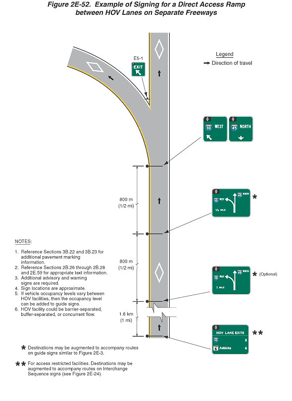
Figure 2E-52. Example of Signing for a Direct Access Ramp between HOV Lanes on Separate Freeways
This figure shows an example of signing for a direct access ramp between HOV lanes on separate freeways.
The figure shows segments of a vertical freeway access ramp. An exit lane is shown curving to the left from the access ramp, which continues straight ahead. Three white HOV diamond symbols are shown on the road surface. The direction of travel is from the bottom to the top of the figure.
A series of six signs are shown , from the bottom to the top of the figure, all of which are shown as mounted over the access ramp except as otherwise noted:
- The first sign is shown near the bottom of the figure and at a dimension of 1.6 km (1 mi) in advance of the second sign. It is shown as a horizontal rectangular green sign with a white border and legend divided into two sections by a horizontal white line that extends from the left to right borders. In the upper section, a white HOV diamond symbol is shown on a black rectangular background in the top left corner of the sign. The words "HOV LANE EXITS" are shown in the top section. In the lower section, a red and blue Interstate shield for Interstate 10 is shown on the top line to the left of the numeral "2." A square white state highway sign for Texas 6 is shown on the bottom line to the left of the word "Addicks," which is to the left of the numeral "6." The numerals are shown vertically aligned near the right edge of the sign. Two asterisks are shown to the right of the sign.
- The second sign is shown at a dimension of 800 m (1/2 mi) in advance of the third sign. It is shown as a horizontal rectangular green sign with a white border and legend. A white HOV diamond symbol is shown on a black rectangular background in the top left corner of the sign. A plan view of the access ramp is shown in the middle of the sign, consisting of a two-headed arrow with the shafts emanating from a common base, with one shaft curving to the left and one going straight up. A dashed green line is shown along the middle of the shaft from the base to the start of the arrowheads. To the left of the base of the arrow shaft, the words "1 MILE" are shown. To the left of the left arrow, the red and blue Interstate route shield for Interstate 10 is shown to the left of the word "WEST." To the right of the upward-pointing arrow, the red and blue Interstate route shield for Interstate 45 is shown to the left of the word "NORTH." One asterisk is shown to the right of the sign with the word "(Optional)." A white HOV diamond symbol is shown on the road surface between the second and third signs.
- The third sign is shown at a dimension of 800 m (1/2 mi) in advance of the fourth and fifth signs. It is shown as identical to the second sign except the words "1 MILE" are replaced by the words "1/2 MILE." One asterisk is shown to the right of the sign.
- The fourth and fifth signs are shown as square green signs with white borders and legends next to each other. Both signs are shown with a white HOV diamond symbol on a black rectangular background in the top left corner of the sign. On the sign on the left, the red and blue Interstate route shield for Interstate 10 is shown to the left of the word "WEST" on the top line, and a short diagonal white arrow pointing up and to the left is shown on the left side of the bottom line. On the sign on the right, the red and blue Interstate route shield for Interstate 45 is shown to the left of the word "NORTH" on the top line, and a short downward-pointing vertical white arrow is shown centered on the bottom line.
- The sixth sign is shown as an E5-1 sign on the gore between the left exit lane and the access ramp lane. It is shown as a square green sign with the white HOV diamond on a rectangular black background in the top left corner of the sign, the word "EXIT" in white on the top line, and a short diagonal white arrow pointing up and to the left on the bottom line.
Beyond the gore, a white HOV diamond symbol is shown on the road surface of both the left exit lane and the access ramp.
A legend shows an arrow indicating the direction of travel on the roadways.
Notes have the following entries:
- Reference Sections 3B.22 and 3B.23 for additional pavement marking information.
- Reference Sections 2B.26 through 2B.28 and 2E.59 for appropriate text information.
- Additional advisory and warning signs are required.
- Sign locations are approximate.
- If the vehicle occupancy levels vary between HOV facilities, then the occupancy level can be added to guide signs.
- HOV facility could be barrier-separated, buffer-separated, or concurrent flow.
A note with one asterisk states: "Destinations may be augmented to accompany routes on guide signs similar to Figure 2E-3."
A note with two asterisks states: "For access restricted facilities. Destinations may be augmented to accompany routes on Interchange Sequence signs (see Figure 2E-24)."
