
Figure 6H-8. Road Closure with Off-Site Detour (TA-8)
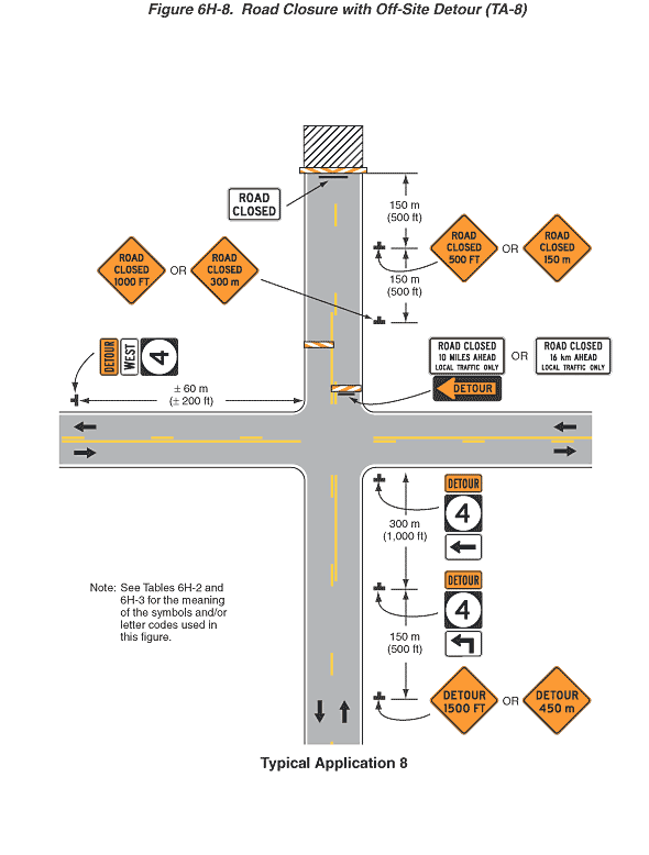
This figure illustrates road closure with an off-site detour. A legend under the figure states that this is Typical Application 8. A note states "Note: See Tables 6H-2 and 6H-3 for the meaning of the symbols and/or letter codes used in this figure."
This figure shows the intersection of a vertical two-lane roadway with a horizontal two-lane roadway. Black arrows in the lanes show that the direction of travel is one lane in each direction for both roadways. A solid white line is shown to the right of each travel lane. On the vertical roadway, a broken yellow line is shown separating the opposing lanes, with a solid yellow line for a short distance to the right of the broken yellow line in both directions at the intersection. On the horizontal roadway, a solid yellow line in both directions is shown to the right of a broken yellow line.
At the bottom of the figure and to the right of the shoulder of the right, northbound lane, a black inverted "T" is shown denoting a sign. The sign shown is a diamond-shaped orange sign with a black border and the words "DETOUR 1500 FT" in black or its metric alternate "450 m." This sign is shown at a dimensioned distance of 150 m (500 ft) in advance of a sign assembly to the right of the right shoulder. The second sign assembly is shown as composed of a horizontal rectangular orange marker with a black border and the word "DETOUR" in black above a vertical rectangular State Route sign with the number "4" in black inscribed within a white circle on a black background. Below the Route sign, a horizontal rectangular white sign with a black border is shown with a right-angled black arrow pointing up and to the left. This sign assembly is shown at a dimensioned distance of 300 m (1000 ft) in advance of another sign assembly shown to the right of the right shoulder at the intersection of the two roadways. This assembly is shown as a State Route 4 sign assembly with a horizontal black arrow pointing to the left. On the left, west side of the horizontal roadway, another State Route 4 sign assembly is shown with a horizontal rectangular white sign with a black border and the word "WEST" in black between a Detour marker and the State Route 4 sign. It is shown to the right of the right, westbound lane at a dimensioned distance of 60 m (200 ft) west of the intersection with the vertical roadway.
Beyond the intersection, on the vertical roadway, a sign is shown mounted on the front of a Type III barricade and placed across the right lane of the vertical roadway. The sign is shown as a white horizontal rectangular sign with a black border and the words "ROAD CLOSED 10 MILES AHEAD LOCAL TRAFFIC ONLY" in black or its metric alternate "16 km." This sign is shown above a horizontal rectangular black sign with an orange border and the word "DETOUR" in black superimposed on a left-pointing horizontal orange arrow. The arrow points to the left. Another Type III barricade is shown placed across the oncoming lane just beyond the one in the right lane, but with no signs on it. Beyond these barricades, to the right of the right shoulder, a diamond-shaped orange sign with a black border is shown with the words "ROAD CLOSED 1000 FT" in black or its metric alternate "300 m." This sign is shown at a dimensioned distance of 150 m (500 ft) in advance of another sign with the words "ROAD CLOSED 500 FT" or the metric alternate "150 m" in black shown to the right of the right shoulder. This sign is shown at a dimensioned distance of 150 m (500 ft) in advance of a horizontal rectangular white sign with a black border and the words "ROAD CLOSED" mounted on the front of a Type III barricade extending on either side of both lanes. This barricade is shown directly in front of a horizontal rectangular black and white diagonally striped box, denoting a work space.