
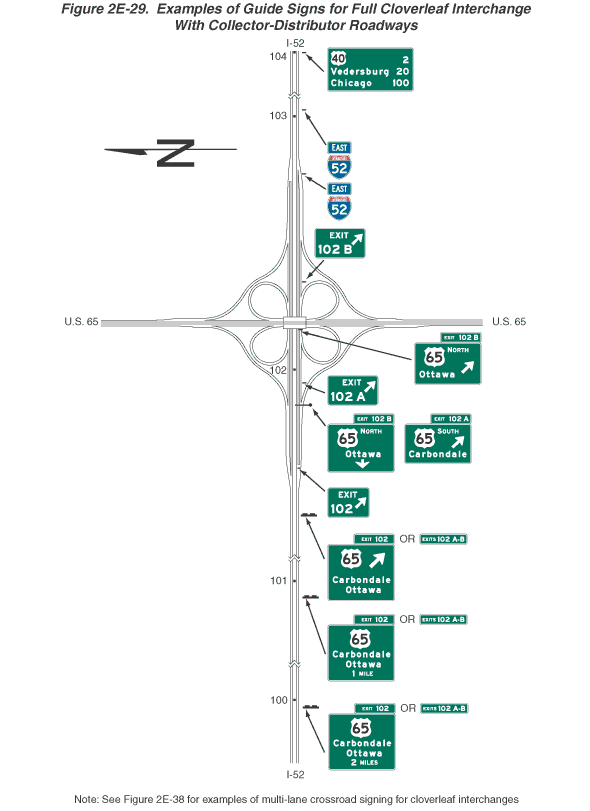
Figure 2E-29. Examples of Guide Signs for Full Cloverleaf Interchange with Collector-Distributor Roadways
This figure shows 20 examples of guide signs for a full cloverleaf interchange with collector-distributor roadways.
The figure shows guide signs for a full cloverleaf interchange of I-52 and U.S. 65. I-52 is shown vertically, and U.S. 65 is shown horizontally. A series of signs and sign assemblies are shown along the highways from the bottom to the top of the figure and from the left to the right. The signs are shown on eastbound I-52 and southbound U.S. 65. Off-route movement in both cases is to the right. On I-52, black dots denoting reference location signs are depicted spaced at intervals along the route. Except as otherwise noted, all signs are horizontal rectangular green signs with white lettering and borders. They display a red and blue Interstate route shield with white numerals or a white U.S. Route shield with black numerals. At the top left of the figure, a black capital letter "N" is shown superimposed on a left-pointing horizontal black arrow, denoting the compass direction. At the bottom of the figure, a note states "See Figure 2E-38 for examples of multi-lane crossroad signing for cloverleaf interchanges."
There are 13 signs or sign assemblies shown on eastbound I-52:
- The first sign on eastbound I-52 is shown at the bottom of the figure to the right of the highway. The shield for U.S. 65 is shown centered on the top line. Below it, the word "Carbondale" is shown on the second line, the word "Ottawa" is shown on the third line, and the words "2 MILES" are shown on the fourth line. A smaller horizontal rectangular green plaque is shown above the top right side of the sign. It shows the words "EXIT 102." To the right of the plaque, the word "OR" is shown and another plaque with the words "EXITS 102 A-B." Just beyond this sign, reference location sign 100 is shown on the median between the northbound and southbound lanes.
- The second sign is shown to the right of the highway and as identical to the first sign except that the words "1 MILE" are shown on the bottom line instead of "2 MILES." Just beyond this sign, reference location sign 101 is shown on the median between the northbound and southbound lanes.
- The third sign is shown to the right of the highway and as identical to the first two signs except that the words "1 MILE" are deleted and a diagonal arrow pointing up and to the right is shown to the right of the U.S. 65 shield.
- The fourth sign is shown in the gore between the through lanes and the first exit lane. It is shown as a smaller horizontal rectangular green sign with the word "EXIT" on the top line and the numerals "102" to the left of a diagonal arrow pointing up and to the right on the bottom line.
- The fifth and sixth signs are shown located over the exit lane just prior to the first exit ramp of the cloverleaf. They are shown as a sign assembly in a horizontal array. On the sign on the left, a U.S. 65 shield is shown on the top line to the left of the word "NORTH." Below it, the word "Ottawa" is shown on the middle line, and a short downward-pointing vertical arrow is shown on the bottom line. A smaller horizontal rectangular green plaque is shown above the top right side of the sign. It shows the words "EXIT 102 B." On the sign on the right, a U.S. 65 shield is shown on the top line to the left of the word "SOUTH." The word "Carbondale" is shown to the left of a diagonal arrow pointing up and to the right on the bottom line. A smaller horizontal rectangular green plaque is shown above the top right side of the sign. It shows the words "EXIT 102 A."
- The seventh sign is shown in the gore between the through lanes and the first exit ramp. It is shown as a smaller horizontal rectangular green sign with the word "EXIT" on the top line and the word "102 A" to the left of a diagonal arrow pointing up and to the right on the bottom line. Just beyond this sign, reference location sign 102 is shown on the median between the northbound and southbound lanes.
- The eighth sign is shown located over the highway on the overpass where U.S. 65 crosses over I-52. The U.S. 65 shield is shown on the top left to the left of the word "NORTH." The word "Ottawa" is shown to the left of a diagonal arrow pointing up and to the right on the bottom line. A smaller horizontal rectangular green plaque is shown above the top right side of the sign. It shows the words "EXIT 102 B."
- The ninth sign is shown in the gore between the through lanes and the second (loop) exit ramp. It is shown as a smaller horizontal rectangular green sign with the word "EXIT" on the top line and the word "102 B" to the left of a large diagonal white arrow pointing up and to the right on the bottom line.
- The 10th sign is shown located to the right of the highway beyond the last entrance ramp to I-52 from U.S. 65. It is shown as a red and blue Interstate route shield for I-52. Above it, a plaque is shown with the word "EAST" in white letters and a white border on a blue background.
- The 11th sign is shown as identical to the previous Interstate route shield. Just prior to this sign, reference location sign 103 is shown on the median between the northbound and southbound lanes.
- The 12th sign is shown farther beyond the interchange ramps to the right of the highway. It is shown as a vertical rectangular white sign with a black border and legend. It shows the words "SPEED LIMIT" on two lines about the large numerals "55."
- The 13th sign is shown at the top of the figure to the right of the roadway at the point where reference location sign 104 is shown on the median between the northbound and southbound lanes. On the top line, a U.S. 40 shield is shown to the left of the numeral "2," on the middle line, the word "Vedersburg" is shown to the left of the numerals "20," and on the bottom line, the word "Chicago" is shown to the left of the numerals "100." The final digits of each numeral are shown aligned vertically near the right edge of the sign.
There are seven guide signs shown on southbound U.S. 65:
- The first sign is shown to the right of the highway. It is shown as a red and blue Interstate route shield for I-52. Above it, a plaque is shown with the word "JCT" in white letters and a white border on a blue background.
- The second and third signs are shown farther south and to the right of the highway. They are shown as a sign assembly in a horizontal array. The sign on the left is shown as a red and blue Interstate route shield for I-52. Above it, a plaque is shown with the word "EAST" in white letters and a white border on a blue background. Below it, a plaque is shown with an upward-pointing vertical white arrow and a white border on a blue background. The sign on the right is shown as the same I-52 shield and two plaques, but the word on the top plaque is shown as "WEST" instead of "EAST," and the arrow on the bottom plaque is shown pointing diagonally up and to the right instead of straight up.
- The fourth and fifth signs are shown located over the highway prior to the first exit ramp of the cloverleaf. They are shown as a sign assembly in a horizontal array. The sign on the left shows the shield for I-52 to the left of the word "EAST" on the top line. Below it, the word "Chicago" is shown on the middle line, and the words "1/4 MILE" are shown on the bottom line. The sign on the right shows the shield for I-52 to the left of the word "WEST" on the top line. Below it, the word "Bloomington" is shown on the bottom line, with a diagonal white arrow pointing up and to the right slightly above the right side of the word "Bloomington."
- The sixth sign is shown is shown in the gore between the through lane and the first exit ramp to I-52. It is shown as a red and blue Interstate route shield for I-52. Above it, a plaque is shown with the word "WEST" in white letters and a white border on a blue background. Below it, a plaque is shown with an diagonal arrow pointing up and to the right.
- The seventh sign is shown to the right of the highway prior to the second loop exit ramp to I-52 from U.S. 65. It shows the Interstate route shield for I-52 to the left of the word "EAST" on the top line. Below it, the word "Chicago" is shown on the bottom line, with a diagonal arrow pointing up and to the right slightly above the right side of the word "Chicago."