
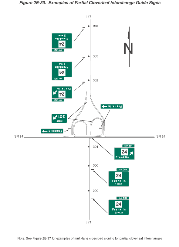
Figure 2E-30. Examples of Partial Cloverleaf Interchange Guide Signs
This figure shows 15 examples of partial cloverleaf interchange guide signs.
The figure shows guide signs for a partial cloverleaf interchange of I-47 and SR 24. I-47 is shown vertically, and SR 24 is shown horizontally. At the top right of the figure, a black capital letter "N" is shown superimposed on an upward-pointing vertical black arrow, denoting the compass direction. At the bottom of the figure, a note states "See Figure 2E-37 for examples of multi-lane crossroad signing for partial cloverleaf interchanges."
A series of signs and sign assemblies are shown along the highways. The direction of travel is from the bottom to the middle of the figure, from the top to the middle of the figure, and from the right to the left of the figure. Off-route movement, in all cases, is to the right. On I-47, black dots denoting reference location signs are depicted spaced at intervals along the route. Except as otherwise noted, all signs are horizontal rectangular green signs with white borders and lettering. They display a red and blue Interstate route shield with white numerals or a white State route square with black numerals.
On northbound I-47, three signs are shown in advance of the SR 24 overpass:
- At the bottom of the figure, the first sign is shown to the right of the highway. It shows a white square on which the black numerals "24" are shown on the top line, the word "Franklin" on the middle line, and the words "2 MILES" on the bottom line. A smaller horizontal rectangular green plaque is shown above the top right side of the sign. It shows the words "EXIT 301." Just beyond this sign, reference location sign 299 is shown on the median between the northbound and southbound lanes.
- The second sign is shown to the right of the highway. The sign and plaque are shown as identical to the first sign, except the words "1 MILE" are shown on the bottom line instead of the words "2 MILES." Just beyond this sign, reference location sign 300 is shown on the median between the northbound and southbound lanes. Just prior to the SR 24 overpass, reference location sign 301 is shown on the median between the northbound and southbound lanes.
- The third sign is shown located over the highway on the overpass where SR 24 crosses over I-47. The sign and plaque are shown as identical to the first sign, except the words "2 MILES" are deleted and a diagonal arrow pointing up and to the right is shown to the right of the word "Franklin."
On southbound I-47, six signs are shown in advance of the SR 24 overpass:
- At the top of the figure, the first sign is shown to the right of the highway at the point where reference location sign 304 is shown on the median between the northbound and southbound lanes. The sign shows a white square on which the black numerals "24" are shown on the top line, the word "Franklin" on the middle line, and the words "2 MILES" on the bottom line. A smaller horizontal rectangular green plaque is shown above the top right side of the sign. It shows the words "EXIT 301."
- The second sign is shown to the right of the highway at the point where reference location sign 303 is shown on the median between the northbound and southbound lanes. The sign and plaque are shown as identical to the first sign, except the words "1 MILE" are shown on the bottom line instead of the words "2 MILES."
- The third sign is shown to the right of the highway at the point where reference location sign 302 is shown on the median between the northbound and southbound lanes. The sign and plaque are shown as identical to the first sign, except the words "2 MILES" are deleted and a diagonal arrow pointing up and to the right is shown to the right of the word "Franklin."
- The fourth sign shows the word "EXIT" on the top line and the numerals "301" on the bottom line to the left of a diagonal arrow pointing up and to the right. This sign is shown in the gore between the through lanes and the right-hand exit ramp to SR 24. It also is shown in the gore between the through lanes and the right-hand exit ramp from northbound I-47 to SR 24.
- The fifth sign is shown on the cloverleaf exit ramp from northbound I-47 to SR 24 just prior to its intersection with SR 24. It shows the word "Franklin" to the left of a horizontal arrow pointing to the right.
- The sixth sign is shown on the exit ramp from southbound I-47 to SR 24 just prior to its intersection with SR 24. It shows the word "Franklin" to the left of a horizontal arrow pointing to the right.
On westbound SR 24, six signs or sign assemblies are shown:
- At the right side of the figure, the first sign is shown to the right of the highway. It is shown as a red and blue Interstate route shield for I-47. Above it, a plaque is shown with the word "JCT" in white letters and a white border on a blue background.
- The second sign is shown to the right of the highway. It is shown with an upward-pointing vertical arrow to the left of the word "Morton" in the top half of the sign above a horizontal white dividing line, separating the sign into two halves. The word "Jackson" is shown to the left of a horizontal arrow pointing to the right in the bottom half of the sign.
- The third and fourth signs are shown to the right of the highway just prior to the first exit ramp to I-47. They are shown as a sign assembly in a horizontal array. The sign on the left is shown as a red and blue Interstate route shield for I-47. Above it, a plaque is shown with the word "SOUTH" in white letters and a white border on a blue background. Below it, a plaque is shown with an upward-pointing vertical white arrow and white border on a blue background. The sign on the right is shown as the same I-47 shield and two plaques, except the word on the top plaque is shown as "NORTH" instead of "SOUTH" and the arrow on the bottom plaque is shown pointing to the right instead of straight up.
- The fifth sign is shown to the right of highway just prior to the point where SR 24 passes over I-47. It is shown as identical to the third plaque, except the arrow on the bottom plaque is shown as a right angle pointing up and to the right.
- The sixth sign is shown to the right of the highway just prior to the second exit ramp to I-47. It shows the red and blue Interstate route shield for I-47 to the left of the word "SOUTH" on the top line, the word "Morton" on the second line, and a horizontal arrow pointing to the right on the third line.