
2009 Edition Part 2 Figure 2D-6. Illustration of Directional Assemblies and Other Route Signs (for One Direction of Travel Only) (Sheet 4 of 4)
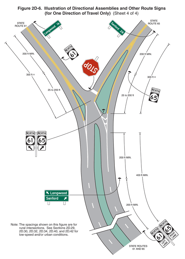
Figure 2D-6. Illustration of Directional Assemblies and Other Route Signs (for One Direction of Travel Only) (Sheet 4 of 4)
Sheet 4 of the figure shows one highway intersection. A note states: "The spacings shown on this figure are for rural intersections. See Sections 2D.29, 2D.30, 2D.32, 2D.34, 2D.40, and 2D.42 for low-speed and/or urban conditions."
A segment of a curving highway is shown running vertically labeled "STATE ROUTES 61 AND 65" intersecting two highways at a "Y" intersection labeled "STATE ROUTE 61" as the left fork and "STATE ROUTE 65" as the right fork. This figure shows left fork and right fork as two-lane roadways with one lane of traffic in each direction. Near the intersection, the opposing lanes of both the left fork and the right fork are shown separated by green islands bordered by solid yellow lines. The vertical highway is shown with two lanes of traffic in each direction separated by broken white lines. The opposing lanes are shown separated by a narrow green island. Near the intersection, the broken white lines are shown changing to solid white lines. The direction of travel is from the bottom to the top of the figure. There are eight sign assemblies shown on these highways, most to the right side of the highways:
- At the bottom of the figure and to the right of the vertical highway, a sign assembly is shown composed of a horizontal rectangular white sign with the word "NORTH" in black mounted above a square black state route sign with the numeral "61" above a horizontal rectangular white sign with the words "LEFT LANE" in black on two lines. To its right, the same sign assembly is shown substituting "65" and the words "RIGHT LANE." The distance from the near side of the fork in the highway to this sign assembly is shown as a dimension of 400 ft MIN.
- Further up the page and to the right of the vertical highway, a horizontal rectangular green sign with a white border and legend is shown. A short diagonal arrow pointing up and to the left is shown to the left of the word "Longwood" on the top line, above a white horizontal line, and the word "Sanford" is shown to the left of a short diagonal arrow pointing up and to right on the bottom line. The distance from this sign to the previous sign assembly is shown as a dimension of 200 ft MIN. and from this sign to the near side of the intersection as a dimension of 200 ft MIN.
- At the intersection, a sign assembly is shown mounted on the island separating the lanes of the horizontal roadway to the right. The sign assembly is shown facing traffic on the vertical highway. It is shown as identical to the first sign assembly except short diagonal arrows pointing up and to the left and right, respectively, are shown instead of the words "LEFT LANE" and "RIGHT LANE."
- On the right fork of the roadway, a red STOP sign is shown at the gore and to the right of the southbound lane of the roadway. Midway along the right fork, a sign assembly is shown to the right of the highway with a horizontal rectangular white sign with the word "NORTH" in black above a square black state route sign with the numeral "65." The distance from the near side of the intersection to this sign assembly is shown as a dimension of 25 to 200 ft.
- Beyond this sign assembly on the right fork of the roadway, a horizontal rectangular green sign with a white border and legend is shown with the word "Sanford" to the left of the numeral "28." The distance from this sign to the previous sign is shown as a dimension of 200 ft MIN. and from this sign to the near side of the intersection to this sign assembly is shown as a dimension of 300 ft +.
- Midway on the left fork, a sign assembly is shown to the right of the roadway with a horizontal rectangular white sign with the word "NORTH" in black above a square black state route sign with the numeral "61." The distance from the near side of the intersection to this sign assembly is shown as a dimension of 25 to 200 ft.
- Beyond this sign assembly on the left fork of the roadway, a horizontal rectangular green sign with a white border and legend is shown with the word "Longwood" to the left of the numeral "16." The distance from this sign to the previous sign is shown as a dimension of 200 ft MIN. and from this sign to the near side of the intersection to this sign assembly is shown as a dimension of 300 ft +.