
2009 Edition Part 2 Figure 2E-21. Example of Interchange Numbering for Overlapping Routes
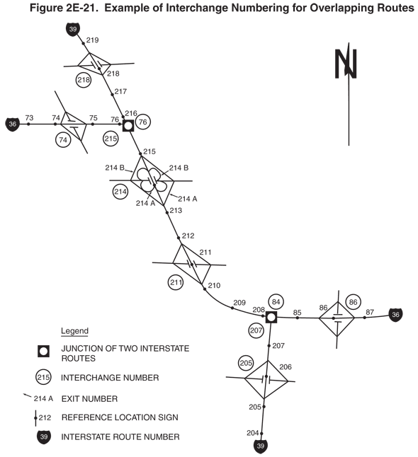
Figure 2E-21. Example of Interchange Numbering for Overlapping Routes
This figure shows an example of interchange numbering for overlapping routes.
The figure shows a map of two Interstate routes: a vertical highway labeled Interstate 39 intersecting a diagonal highway running east-west. The diagonal highway is labeled Interstate 36 on east and west highways that branch of off Interstate 39.
At the top right of the figure, a black capital letter "N" is shown superimposed on an upward-pointing vertical black arrow, denoting the compass direction. A legend at the bottom of the figure shows a white disc superimposed on a black square, labeled "JUNCTION OF TWO INTERSTATE ROUTES"; the numeral "215" inside a black circle, labeled "INTERCHANGE NUMBER"; the notation "214A," labeled "EXIT NUMBER"; a black dot superimposed on a vertical black line next to the numeral "212," labeled "REFERENCE LOCATION SIGN," and an Interstate route shield with the numeral "39," labeled "INTERSTATE ROUTE NUMBER."
On all three routes, black dots denoting reference location signs accompanied by numbers are depicted spaced at intervals along the route, and each of the exits is shown with an interchange number.
This description first lists the Interstate 39 interchanges and then the Interstate 36 interchanges. On both routes, the exits are shown numbered according to the reference location sign exit numbering, rather than consecutively.
At the bottom of the figure, Interstate 39 is shown proceeding from south to north. It shows the following interchanges and numbered reference location signs:
- Reference location sign 204
- Reference location sign 205
- Interchange 205, a diamond interchange, and reference location sign 206
- Reference location sign 207
- Interchange 207, the junction with Interstate 36. This is also interchange 84 on Interstate 36.
- Reference location sign 208
- Reference location sign 209
- Reference location sign 210
- Interchange 211, a diamond interchange, and reference location sign 211
- Reference location sign 212
- Reference location sign 213
- Interchange 214 and reference location sign 214. Interchange 214 is a cloverleaf, with Exits 214A and 214B in each direction. In the northbound direction, Exit 214A is shown preceding 214B. In the southbound direction, Exit 214B is shown preceding 214A.
- Reference location sign 215
- Interchange 215, which is the junction where Interstate 36 and Interstate 39 split. This is also interchange 76 on Interstate 36.
- Reference location sign 216
- Reference location sign 217
- Interchange 218, a diamond interchange, and reference location sign 218
- Reference location sign 219.
On the left side of the figure, Interstate 36 is shown proceeding from west to east, overlapping a portion of Interstate 39. From west to east, it shows the following interchanges and numbered reference location signs:
- Reference location sign 73
- Reference location sign 74
- Interchange 74, a diamond interchange
- Reference location sign 75
- Reference location sign 76
- Interchange 76, the north junction with Interstate 39. This is also interchange 215 on Interstate 39. Interstate 36 then overlaps Interstate 39 until interchange 84.
- Interchange 84, the south junction with Interstate 39. This is also interchange 207 on Interstate 39.
- Reference location sign 85
- Interchange 86, a diamond interchange, and reference location sign 86
- Reference location sign 87.