|
|
2009 Edition Part 2 Figure 2G-20. Example of a Comparative Travel Time Information Sign for Preferential or Managed Lanes

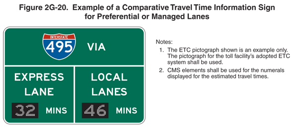
Figure 2G-20. Example of a Comparative Travel Time Information Sign for Preferential or Managed Lanes
This figure shows an example of a comparative travel time information sign for preferential or managed lanes.
The following notes are shown:
- The ETC pictograph that is shown is an example only. The pictograph for the toll facility's adopted ETC system shall be used.
- CMS elements shall be used for the numerals displayed for the estimated travel times.
The sign is shown as a horizontal rectangular green sign with white letters and a white border. At the top of the sign, a red and blue Interstate shield for I-495 is shown to the left of the word "VIA" on one line. Under this legend, a horizontal white line extends from the left border to the right border, separating the sign into two horizontal portions. A vertical white line extends from the horizontal dividing line to the bottom border, separating the lower part of the sign into two parts. In the lower left portion of the sign, the words "EXPRESS LANE" are shown on two lines above a changeable message, represented by a black rectangle with the numeral "19" composed of white dots, to the left of the word "MINS." In the lower right portion of the sign, the words "LOCAL LANES" are shown on two lines above a changeable message, represented by a black rectangle with the numeral "29" composed of white dots, to the left of the word "MINS."
