|
|
2009 Edition Part 2 Figure 2M-2. Examples of Recreational and Cultural Interest Area Guide Signs

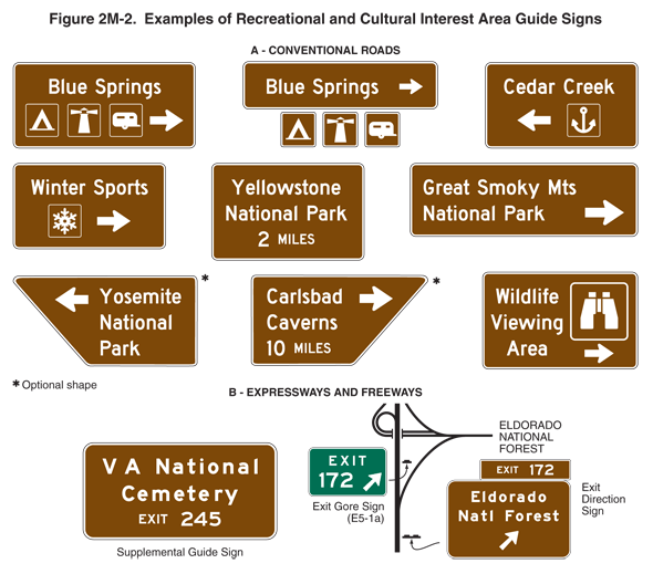
Figure 2M-2. Examples of Recreational and Cultural Interest Area Guide Signs
This figure shows 11 examples of recreational and cultural interest area guide signs. The illustrations show horizontal rectangular or trapezoidal brown signs with white words, symbols, arrows, and borders.
The first nine examples are labeled "A – conventional roads." The first illustration shows a horizontal rectangular sign with the words "Blue Springs" on the top line and, on the bottom line, three symbols showing a tent, lighthouse, and trailer, each enclosed within a square white border, to the left of a right-pointing horizontal arrow.
The second illustration shows a horizontal rectangular sign assembly with a horizontal rectangular top panel with the words "Blue Springs" to the left of a right-pointing horizontal arrow mounted above a horizontal row of three separate square symbol signs showing a tent, lighthouse, and trailer.
The third illustration shows a horizontal rectangular sign with the words "Cedar Creek" on the top line and, on the bottom line, a left-pointing horizontal arrow to the left of an anchor enclosed in a square border.
The fourth illustration shows a horizontal rectangular sign with the words "Winter Sports" on the top line and, on the bottom line, a snowflake enclosed in a square border to the left of a right-pointing horizontal arrow
The fifth illustration shows a horizontal rectangular sign with the words "Yellowstone" on the top line, "National Park" on the middle line, and "2 MILES" on the bottom line.
The sixth illustration shows a horizontal rectangular sign with the words "Great Smoky Mts" on the top line and, on the bottom line, the words "National Park" to the left of a right-pointing horizontal arrow.
The seventh illustration shows a left-pointing trapezoid-shaped sign (with the left edge of the trapezoid running diagonally downward and to the left) with a left-pointing horizontal arrow and the word "Yosemite" on the top line, the word "National" on the middle line, and the word "Park" on the bottom line. This sign is noted as "Optional shape."
The eighth illustration shows a right-pointing trapezoid-shaped sign (with the right edge of the trapezoid running diagonally downward and to the right) with the word "Carlsbad" and a right-pointing horizontal arrow on the top line, the word "Caverns" on the middle line, and the words "10 MILES" on the bottom line. This sign is noted as "Optional shape."
The ninth illustration shows a horizontal rectangular sign with the words "Wildlife Viewing Area" on three lines on the left half of the sign and, on the right half of the sign, a symbol showing binoculars within a square white border above a right-pointing horizontal arrow.
The last two examples are labeled "B – expressways and freeways." The 10th illustration shows a horizontal rectangular sign with the words "V A National" on the top line, "Cemetery" on the middle line, and "EXIT 245" on the bottom line. It is labeled "Supplemental Guide Sign."
The 11th illustration shows a schematic depiction of highway interchange. A vertical highway is shown with an exit angling to the right to join a horizontal highway with the notation "Eldorado National Forest." An exit direction sign is shown to the right of the highway in advance of the exit. It is shown as a horizontal rectangular brown sign with a white border and legend, with the words "Eldorado Natl Forest" on two lines above a short diagonal arrow pointing up and to the right. A small horizontal rectangular brown plaque with a white border and legend is shown mounted above the top right of the sign with the words "EXIT 172." An E5-1a exit gore sign is shown in the gore just beyond the right exit. It is shown as a horizontal rectangular green sign with a white border and legend, with the word "EXIT" on the top line and, on the second line, the numeral "172" to the left of a short diagonal arrow pointing up and to the right.
