
|
|
2009 Edition Part 6 Figure 6H-21. Lane Closure on the Near Side of an Intersection (TA-21)
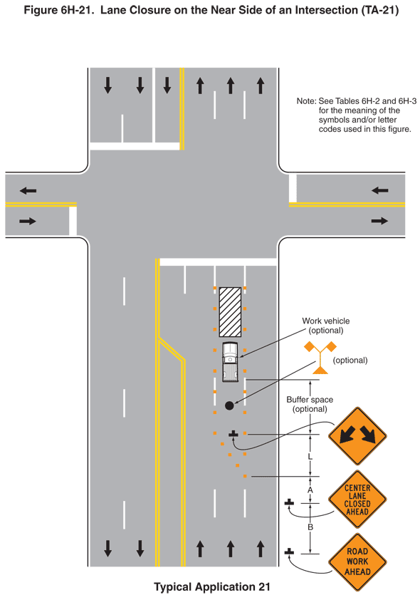
Figure 6H-21. Lane Closure on the Near Side of an Intersection (TA-21)
This illustration shows an example of lane closure on the near side of an intersection. A legend under the figure states that this is Typical Application 21. A note states "See Tables 6H-2 and 6H-3 for the meaning of the symbols and/or letter codes used in this figure."
This figure shows a vertical six-lane roadway intersecting a two-lane horizontal roadway near the top of the page. The opposing lanes on both roadways are shown separated by solid double yellow lines. Broad white lines perpendicular to the travel lanes show where vehicles must stop before entering the intersection in all four directions.
At the bottom of the figure, five lanes are shown marked on the six-lane roadway. Two lanes are shown in the southbound direction on the left, separated by a broken white line. A downward-pointing black arrow in each of the two lanes denotes the direction of travel. To the right of the second lane from the left, an area the width of a lane is shown marked off on both sides by solid double yellow lines. These lines are shown extending parallel to one another from the bottom of the figure to south of the intersection with the horizontal roadway where the double line on the right is shown jogging diagonally to the left and joining the leftmost double line still south of the intersection. The double line then is shown continuing to the solid white transverse line on the south side of the vertical roadway, forming a left turn lane. The right half of the roadway shows three northbound lanes separated by broken white lines. An upward-pointing black arrow in each of the three lanes on the right-hand side denotes the direction of travel.
At the bottom of the figure to the right of the northbound lanes, a black inverted "T" is shown denoting a sign. It is shown as a diamond-shaped orange sign with a black border and the words "ROAD CLOSED AHEAD" in black. Beyond this sign at a dimensioned distance B, another diamond-shaped orange sign with a black border is shown with the words "CENTER LANE CLOSED AHEAD" in black. Beyond this sign in the center northbound lane, at a dimensioned distance A, a series of five orange squares is shown, denoting channelizing devices. They are shown beginning on the right side of the center lane and tapering diagonally up and to the left side of the center lane. The devices are shown continuing along the left side of the center lane from the point where they meet the left-hand lane marking to the intersection. The devices also are shown running along the broken white line on the right side of the center lane from the point where the devices move left across the road to where the lane meets the intersection.
Above the channelizing devices just to the right of the middle of the center lane, a black inverted "T" is shown denoting a sign. It is shown as a diamond-shaped orange sign with a black border and two black arrows, one pointing diagonally down to the left and the other diagonally down to the right. This sign is shown at a dimensioned distance L beyond the beginning of the channelizing devices. Beyond this sign in the middle of the center lane, a filled black circle is shown. It shows the placement of a high-level flag tree. A leader arrow points from the orange flag tree symbol to the black circle. The flag tree is labeled optional. Beyond the black circle, a work vehicle symbol labeled optional is shown. The vehicle is shown in the middle of the center lane facing the direction of travel. A space between the double arrow symbol sign and the work vehicle is shown as a dimensioned buffer space labeled optional. Above the work vehicle symbol, a vertical white rectangle with black and white diagonal lines is shown, denoting a work space.
On the far side of the intersection with the horizontal roadway at the top of the figure, six lanes are shown marked on the vertical roadway. Three lanes are shown in the southbound direction on the left. The first and second lanes from the left are shown separated by a broken white line. The second and third lanes from the left are shown separated by a solid white line. A downward-pointing black arrow in each of the three lanes denotes the direction of travel. Three lanes are shown in the northbound direction on the right, separated by a broken white line. An upward-pointing black arrow in each lane denotes the direction of travel.