
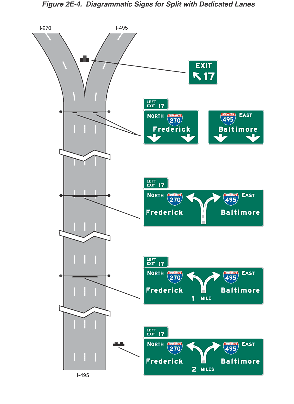
Figure 2E-4. Diagrammatic Signs for Split with Dedicated Lanes
This figure shows diagrammatic signs for a split with dedicated lanes.
The figure shows segments of one direction of a vertical highway labeled I-495 depicted with four lanes, with the travel direction from the bottom to the top of the figure. Near the top of the figure, the highway is shown with a Y-shaped divergence of two lanes to the left fork (labeled I-270) and two lanes to the right fork (labeled I-495). A series of horizontal rectangular green signs and sign assemblies, all with white legends and borders, are shown along the highway from the bottom to the top of the figure.
The first sign is shown to the right of the highway. It is shown with a plan view of the Y-shaped highway divergence in the middle of the sign, consisting of a two-headed arrow with the two arrow shafts emanating from a combined base, with one shaft curving upward and to the left and the other curving upward and to the right. A vertical dashed green line is shown along the middle of the combined shaft, and each shaft is shown with a dashed green line along the middle of the shaft from the base to the start of the arrowhead. Directly below the base of the arrow shafts, the words "2 MILES" are shown:
- To the left of the plan view, on the top line, the word "NORTH" is shown to the left of a red and blue Interstate route shield on which the white numerals "270" are shown, and the word "Frederick" is shown on the bottom line.
- To the right of the plan view, on the top line, a red and blue Interstate route shield is shown on which the white numerals "495" are shown to the left of the word "EAST," and the word "Baltimore" is shown on the bottom line.
- A smaller green horizontal rectangular plaque is shown above the top left side of the sign. It is shown with the word "LEFT" on the top line and the words "EXIT" and "17" on the bottom line.
- The second sign is shown located over the centermost two lanes of the highway. This sign and its plaque are shown as identical to the first sign and plaque except that the words underneath the base of the arrow shafts in the center of the sign are "1 MILE" instead of "2 MILES."
The third sign is also shown located over the centermost two lanes of the highway. This sign and its plaque are shown as identical to the first and second signs and their plaques except that the words under the base of the arrow shafts at the center of the sign are deleted.
Just below the point of divergence of the two forks of the highway, a sign assembly is shown located over the highway. The assembly consists of two signs in a horizontal array:
- The left sign is shown located above the lane line that separates the two leftmost lanes. It shows, on the top line, the word "NORTH" to the left of a red and blue Interstate route shield on which the white numerals "270" are shown, the word "Frederick" on the middle line, and two downward-pointing vertical white arrows with short shafts on the bottom line. A smaller green horizontal rectangular plaque is shown above the top left side of the left sign. It shows the word "LEFT" on the top line and "EXIT" and "17" on the bottom line.
- The right sign is shown located above the lane line that separates the two rightmost lanes. It shows, on the top line, a red and blue Interstate route shield on which the white numerals "495" are shown to the left of the word "EAST," the word "Baltimore" on the middle line, and two downward-pointing vertical white arrows with short shafts on the bottom line.
Just above the point of divergence, between the two forks of the highway, a sign is shown with the word "EXIT" on the top line and a large diagonal arrow pointing upward and to the left to the left of the numerals "17."