
Chapter 2I. Emergency Management Signing
Section 2I.01 Emergency Management
Guidance:
Contingency planning for an emergency evacuation should be considered
by all State and local jurisdictions and should consider the use
of all applicable roadways.
In the event of a disaster where highways that cannot be used will be closed, a successful contingency plan should account for the following elements: a controlled operation of certain designated highways, the establishment of traffic operations for the expediting of essential traffic, and the provision of emergency centers for civilian aid.
Section 2I.02 Design of Emergency Management Signs
Standard:
Emergency Management signs shall be used to guide and control highway
traffic during an emergency.
Emergency Management signs shall not permanently displace any of the standard signs that are normally applicable.
Advance planning for transportation operations' emergencies shall be the responsibility of State and local authorities. The Federal Government shall provide guidance to the States as necessitated by changing circumstances.
The sizes for Emergency Management signs shall be as shown in Table 2I-1.
Guidance:
As conditions permit, the Emergency Management signs should be replaced
or augmented by standard signs.
The background of Emergency Management signs should be retroreflective.
Because Emergency Management signs might be needed in large numbers for temporary use during an emergency, consideration should be given to their fabrication from any light and economical material that can serve through the emergency period.
Option:
Any Emergency Management sign may be accompanied by a standard triangular
plaque for marking areas contaminated by biological and chemical
warfare agents and radioactive fallout.
| Sign | MUTCD Code | Section | Conventional Road | Expressway | Freeway | Minimum | Oversized |
|---|---|---|---|---|---|---|---|
| Evacuation Route | EM-1 | 2I.03 |
600 x 600 (24 x 24) |
— | — | 450
x 450 (18 x 18) |
— |
| Area Closed | EM-2 | 2I.04 | 750
x 600 (30 x 24) |
— | — | — | — |
| Traffic Control Point | EM-3 | 2I.05 | 750
x 600 (30 x 24) |
— | — | — | — |
| Maintain Top Safe Speed | EM-4 | 2I.06 | 600
x 750 (24 x 30) |
— | — | — | — |
| Permit Required | EM-5 | 2I.07 | 600
x 750 (24 x 30) |
— | — | — | — |
| Emergency Aid Center | EM-6a to EM-6d | 2I.08 | 750
x 600 (30 x 24) |
— | — | — | — |
| Directional Shelter | EM-7a to EM-7d | 2I.09 |
750 x 600 |
— | — | — | — |
Notes:
- Larger signs may be used when appropriate
- Dimensions are shown in millimeters followed by inches in parentheses and are shown as width x height
Section 2I.03 EVACUATION ROUTE Sign (EM-1)
Standard:
The EVACUATION ROUTE (EM-1) sign (see Figure 2I-1) shall be a rectangular
sign with a blue circular symbol with a directional arrow and the
legend EVACUATION ROUTE. The diameter of the circular symbol shall
be 25 mm (1 in) smaller than the width of the sign.
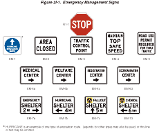
Figure 2I-1 Emergency Management Signs
Option:
An approved Emergency Management symbol may appear near the bottom
of the sign with a diameter of 87 mm (3.5 in).
Standard:
The legend and arrow of the EVACUATION ROUTE sign shall be white
on a blue circular background. The corners of the sign outside of
the circle shall be white. The entire sign shall be retroreflective.
The arrow designs shall include a straight, vertical arrow pointing
upward, a straight horizontal arrow pointing to the left or right,
or a bent arrow pointing to the left or right for advance warning
of a turn.
If used, the EVACUATION ROUTE sign, with the appropriate arrow, shall be installed 45 to 90 m (150 to 300 ft) in advance of, and at, any turn in an approved evacuation route. The sign shall also be installed elsewhere for straight-ahead confirmation where needed.
If used in urban areas, the EVACUATION ROUTE sign shall be mounted at the right-hand side of the roadway, not less than 2.1 m (7 ft) above the top of the curb, and at least 0.3 m (1 ft) back from the face of the curb. If used in rural areas, it shall be not less than 2.1 m (7 ft) above the pavement and 1.8 to 3 m (6 to 10 ft) to the right side of the roadway edge.
EVACUATION ROUTE signs shall not be placed where they will conflict with other signs. Where conflict in placement would occur between the EVACUATION ROUTE sign and a standard regulatory sign, the regulatory sign shall take precedence.
Option:
The legend on the EVACUATION ROUTE sign may be modified to describe
the type of evacuation route, such as HURRICANE.
In case of conflict with guide or warning signs, the Emergency Management sign may take precedence.
Guidance:
Placement of EVACUATION ROUTE signs should be made under the supervision
of the officials having jurisdiction over the placement of other
traffic signs. Coordination with Emergency Management authorities
and agreement between contiguous political entities should occur
to assure continuity of routes.
Option:
The arrow may be a separate panel attached to the face of the sign.
Section 2I.04 AREA CLOSED Sign (EM-2)
Standard:
The AREA CLOSED (EM-2) sign (see Figure 2I-1)
shall be used to close a roadway in order to prohibit traffic from
entering the area. It shall be installed on the shoulder as near
as practical to the right edge of the roadway, or preferably, on
a portable mounting or barricade partly or entirely in the roadway.
Guidance:
For best visibility, particularly at night, the sign height should
not exceed 1.2 m (4 ft) from the pavement to the bottom of the sign.
Unless adequate advance warning signs are used, it should not be
placed to create a complete and unavoidable blocked route. Where
feasible, the sign should be located at an intersection that provides
a detour route.
Section 2I.05 TRAFFIC CONTROL POINT Sign (EM-3)
Standard:
The TRAFFIC CONTROL POINT (EM-3) sign (see Figure 2I-1) shall be
used to designate a location where an official traffic control point
has been set up to impose such controls as are necessary to limit
congestion, expedite emergency traffic, exclude unauthorized vehicles,
or protect the public.
The sign shall be installed in the same manner as the AREA CLOSED sign (see Section 2I.04), and at the point where traffic must stop to be checked.
The standard STOP (R1-1) sign shall be used in conjunction with the TRAFFIC CONTROL POINT sign. The TRAFFIC CONTROL POINT sign shall consist of a black legend and border on a retroreflectorized white background.
Guidance:
The TRAFFIC CONTROL POINT sign should be mounted directly below
the STOP sign.
Section 2I.06 MAINTAIN TOP SAFE SPEED Sign (EM-4)
Option:
The MAINTAIN TOP SAFE SPEED (EM-4) sign (see Figure
2I-1) may be used on highways where conditions are such that
it is prudent to evacuate or traverse an area as quickly as possible.
Where an existing Speed Limit (R2-1) sign is in a suitable location, the MAINTAIN TOP SAFE SPEED sign may conveniently be mounted directly over the face of the speed limit sign that it supersedes.
Support:
Since any speed zoning would be impractical under such emergency
conditions, no minimum speed limit can be prescribed by the MAINTAIN
TOP SAFE SPEED sign in numerical terms. Where traffic is supervised
by a traffic control point, official instructions will usually be
given verbally, and the sign will serve as an occasional reminder
of the urgent need for maintaining the proper reasonably safe speed.
Guidance:
The sign should be installed as needed, in the same manner as other
standard speed signs.
Standard:
If used in rural areas, the MAINTAIN TOP SAFE SPEED sign shall be
mounted on the right side of the road with its lower edge not less
than 1.5 m (5 ft) above the pavement, 1.8 to 3 m (6 to 10 ft) from
the roadway edge. If used in urban areas, the height shall be not
less than 2.1 m (7 ft), and the nearest edge of the sign shall be
not less than 0.3 m (1 ft) back from the face of the curb.
Section 2I.07 ROAD (AREA) USE PERMIT REQUIRED FOR THRU TRAFFIC Sign (EM-5)
Support:
The intent of the ROAD (AREA) USE PERMIT REQUIRED FOR THRU TRAFFIC
(EM-5) sign (see Figure 2I-1) is to notify road users of the presence
of the traffic control point so that those who do not have priority
permits issued by designated authorities can take another route,
or turn back, without making a needless trip and without adding
to the screening load at the post. Local traffic, without permits,
can proceed as far as the traffic control post.
Standard:
If used, the ROAD (AREA) USE PERMIT REQUIRED FOR THRU TRAFFIC (EM-5)
sign shall be used at an intersection that is an entrance to a route
on which a traffic control point is located.
If used, the sign shall be installed in a manner similar to that of the MAINTAIN TOP SAFE SPEED sign (see Section 2I.06).
Section 2I.08 Emergency Aid Center Signs (EM-6 Series)
Standard:
In the event of emergency, State and local authorities shall establish
various centers for civilian relief, communication, medical service,
and similar purposes. To guide the public to such centers a series
of directional signs shall be used.
Emergency Aid Center (EM-6 series) signs (see Figure 2I-1) shall carry the designation of the center and an arrow indicating the direction to the center. They shall be installed as needed, at intersections and elsewhere, on the right side of the roadway, at a height in urban areas of at least 2.1 m (7 ft), and not less than 0.3 m (1 ft) back from the face of the curb, and in rural areas at a height of 1.5 m (5 ft), 1.8 to 3 m (6 to 10 ft) from the roadway edge.
Emergency Aid Center signs shall carry one of the following legends, as appropriate, or others designating similar emergency facilities:
- MEDICAL CENTER (EM-6a)
- WELFARE CENTER (EM-6b)
- REGISTRATION CENTER (EM-6c)
- DECONTAMINATION CENTER (EM-6d)
The Emergency Aid Center sign shall be a horizontal rectangle. The identifying word and the word CENTER, the directional arrow, and the border shall be on a white background.
Section 2I.09 Shelter Directional Signs (EM-7 Series)
Standard:
Shelter Directional (EM-7 Series) signs (see Figure
2I-1) shall be used to direct the public to selected shelters
that have been licensed and marked for emergency use.
The installation of Shelter Directional signs shall conform to established highway signing standards. Where used, the signs shall not be installed in competition with other necessary highway guide, warning, and regulatory signs.
The Shelter Directional sign shall be a horizontal rectangle. The identifying word and the word SHELTER, the directional arrow, the distance to the shelter, and the border shall be black on a white background.
Option:
The distance to the shelter may be omitted from the sign when appropriate.
Shelter Directional signs may carry one of the following legends, or others designating similar emergency facilities:
- EMERGENCY (EM-7a)
- HURRICANE (EM-7b)
- FALLOUT (EM-7c)
- CHEMICAL (EM-7d)
If appropriate, the name of the facility may be used.
The Shelter Directional signs may be installed on the Interstate Highway System or any other major highway system when it has been determined that a need exists for such signs as part of a State or local shelter plan.
The Shelter Directional signs may be used to identify different routes to a shelter to provide for rapid movement of large numbers of persons.
Guidance:
The Shelter Directional sign should be used sparingly and only in
conjunction with approved plans of State and local authorities.
As a general rule, the Shelter Directional sign should not be posted more than 8 km (5 mi) from a shelter.