
Chapter 2E. Guide Signs—Freeways and Expressways
Section 2E.46 Diamond Interchange in Urban Area
Support:
Examples of guide signs for diamond interchanges in an urban area
are shown in Figure 2E-32. This example includes the use of the
Community Interchanges Identification sign (see Section
2E.38) which might be useful if two or more interchanges serve
the same community.
Figure 2E-32 Examples of Diamond Interchange Guide Signs in an Urban Area
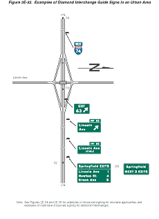
In urban areas, street names are often shown as the principal message in destination signs.
Option:
If interchanges are too closely spaced to properly locate the Advance
Guide signs, they may be placed closer to the exit, and the distance
figures adjusted accordingly.
Section 2E.47 Closely Spaced Interchanges
Option:
When a series of interchanges is closely spaced, the advance guide
sign for the next interchange may be mounted on an overhead structure
located downstream from the gore of the preceding interchange.
Guidance:
Interchange Sequence signs should be used at closely spaced interchanges.
When used, they should identify and show street names and distances
for the next two or three exits as shown in Figure
2E-23.
Standard:
Advance Guide signs for closely spaced interchanges shall show information
for only one interchange.
Section 2E.48 Minor Interchange
Option:
Less signing may be used for minor interchanges because such interchanges
customarily serve low volumes of local traffic.
Support:
Examples of guide signs for minor interchanges are shown in Figure
2E-33.
Figure 2E-33 Examples of Minor Interchange Guide Signs
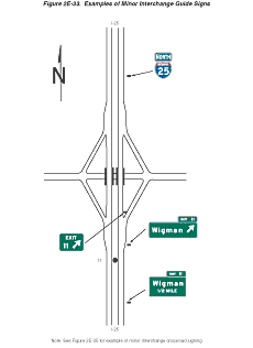
Standard:
At least one Advance Guide sign and an Exit Gore sign shall be placed
at a minor interchange.
Guidance:
An Exit Direction sign should also be used.
Section 2E.49 Signing of Approaches and Connecting Roadways
Support:
Because there are a number of different ramp configurations that
are commonly used at interchanges with conventional roads, drivers
on the conventional road cannot reliably predict whether they will
be required to turn left or right in order to enter the correct
ramp to access the freeway or expressway in the desired direction
of travel. Consistently applied signing for conventional road approaches
to freeway or expressway interchanges is highly desirable.
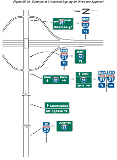
Guidance:
The signing of conventional roads with one lane of traffic approaching
an interchange should consist of a sequence containing the following
signs (see Figure 2E-34):
- Junction Assembly
- Destination sign
- Directional Assembly or Entrance Direction sign for the first ramp
- Advance Route Turn Assembly or Advance Entrance Direction sign with an advance turn arrow
- Directional Assembly or Entrance Direction sign for the second ramp
Figure 2E-34 Example of Signing for a One-Lane Approach
Standard:
If used, the Entrance Direction sign shall consist of a white legend
and border on a green background. It shall contain the freeway or
expressway route shield(s), cardinal direction, and directional
arrow(s).
Option:
The Entrance Direction sign may contain a destination(s) and/or
an action message such as NEXT RIGHT.
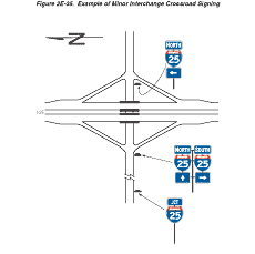
At minor interchanges, the following sequence of signs may be used (see Figure 2E-35):
- Junction Assembly
- Directional Assembly for the first ramp
- Directional Assembly for the second ramp
Figure 2E-35 Example of Minor Interchange Crossroad Signing
Guidance:
On multi-lane conventional roads approaching an interchange, the
sign sequence should contain the following signs (see Figures 2E-36,
2E-37, and 2E-38):
- Junction Assembly
- Advance Entrance Direction sign(s) for both directions (if applicable) of travel on the freeway or expressway
- Entrance Direction sign for first ramp
- Advance Turn Assembly
- Entrance Direction sign for the second ramp
Figure 2E-36 Examples of Multi-lane Crossroad Signing for Diamond Interchange
Figure 2E-37 Examples of Multi-lane Crossroad Signing for Partial Cloverleaf Interchange
Figure 2E-38 Examples of Multi-lane Crossroad Signing for Cloverleaf Interchange
Support:
Advance Entrance signs are used to direct road users to the appropriate
lane(s).
Standard:
The Advance Entrance sign shall consist of a white legend and border
on a green background. It shall contain the freeway or expressway
route shield(s) and cardinal direction(s).
Option:
The Advance Entrance sign may have destinations, directional arrows,
and/or an action message such as LEFT LANE, NEXT LEFT, or SECOND
RIGHT. Signs in this sequence may be mounted overhead to improve
visibility.
Section 2E.50 Wrong-Way Traffic Control at Interchange Ramps
Standard:
At interchange exit ramp terminals where the ramp intersects a crossroad
in such a manner that wrong-way entry could inadvertently be made,
the following signs shall be used (see Figure 2E-39):
- At least one ONE WAY sign for each direction of travel on the crossroad shall be placed where the exit ramp intersects the crossroad.
- At least one DO NOT ENTER sign shall be conspicuously placed near the end of the exit ramp in positions appropriate for full view of a road user starting to enter wrongly.
- At least one WRONG WAY sign shall be placed on the exit ramp facing a road user traveling in the wrong direction.
Figure 2E-39 Examples of Regulatory Signing and Pavement Markings at Exit Ramp Termination to Deter Wrong-Way Entry
Guidance:
In addition, the following pavement markings should be used (see
Figure 2E-39):
- On two-lane paved crossroads at interchanges, double solid yellow lines should be used as a centerline for an adequate distance on both sides approaching the ramp intersections.
- Where crossroad channelization or ramp geometrics do not make wrong-way movements difficult, a lane-use arrow should be placed in each lane of an exit ramp near the crossroad terminal where it will be clearly visible to a potential wrong-way road user.
Option:
The following traffic control devices may be used to supplement
the above signs and pavement markings:
- Additional ONE WAY signs may be placed, especially on two-lane rural crossroads, appropriately in advance of the ramp intersection to supplement the required ONE WAY sign(s).
- Additional WRONG WAY signs may be used.
- Slender, elongated wrong-way arrow pavement markings (see Figure 3B-21) intended primarily to warn wrong-way road users that they are traveling in the wrong direction may be placed upstream from the ramp terminus (see Figure 2E-39), to indicate the correct direction of traffic flow. Wrong-way arrow pavement markings may also be placed on the exit ramp at appropriate locations near the crossroad junction to indicate wrong-way movement. The wrong-way arrow markings may consist of pavement markings or bidirectional red-and-white raised pavement markers or other units that show red to wrong-way road users and white to other road users (see Figure 3B-21).
- Lane-use arrow pavement markings may be placed on the exit ramp and crossroad near their intersection to indicate the permissive direction of flow.
- Guide signs may be used on entrance ramps near the crossroad to inform road users of the freeway or expressway entrance, as appropriate (see Figure 2E-37).
Guidance:
On interchange entrance ramps where the ramp merges with the through
roadway and the design of the interchange does not clearly make
evident the direction of traffic on the separate roadways or ramps,
a ONE WAY sign visible to traffic on the entrance ramp and through
roadway should be placed on each side of the through roadway near
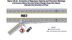
the entrance ramp merging point as illustrated in Figure 2E-40.
Figure 2E-40 Examples of Regulatory Signing and Pavement Markings at Entrance Ramp Terminal Where Design Does Not Clearly Indicate the Direction of Flow
Option:
At locations where engineering judgment determines that a special
need exists, other standard warning or prohibitive methods and devices
may be used as a deterrent to the wrong-way movement.
Support:
Section 2B.35 contains further
information on signing to avoid wrong-way movements at-grade intersections
on expressways.
Section 2E.51 General Service Signs
Support:
General Service signs (see Figure
2D-11) are generally not appropriate at major interchanges (see
Section 2E.29 for definition)
and in urban areas.
Option:
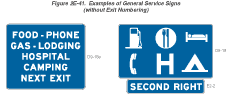
If interchanges are not numbered, an action message such as NEXT
EXIT or SECOND RIGHT may be used (see Figure 2E-41).
Figure 2E-41 Examples of General Service Signs (Without Exit Numbering)
Standard:
General Service signs shall have white letters, symbols, and borders
on a blue background. Letter and numeral sizes shall conform to
the minimum requirements of Tables 2E-1
through 2E-4.
All approved symbols shall be permitted as alternatives to word
messages, but symbols and word service messages shall not be intermixed.
If the services are not visible from the ramp of a single-exit interchange,
the service signing shall be repeated in smaller size at the intersection
of the exit ramp and the crossroad. Such service signs shall use
arrows to indicate the direction to the services.
Guidance:
Distance to services should be shown on General Service signs where
distances are more than 2 km or 1 mile.
General Service signing should only be provided at locations where the road user can return to the freeway or expressway and continue in the same direction of travel.
Only services that fulfill the needs of the road user should be shown on General Service signs. If State or local agencies elect to provide General Service signing, there should be a statewide policy for such signing and criteria for the availability of the various types of services. The criteria should consider the following:
- Gas, Diesel, LP Gas, EV Charging, and/or other alternative fuels
if all of the following are available:
- Vehicle services such as gas, oil, and water;
- Modern sanitary facilities and drinking water;
- Continuous operations at least 16 hours per day, 7 days per week; and
- Public telephone.
- Food if all of the following are available:
- Licensing or approval, where required;
- Continuous operation to serve at least two meals per day, at least 6 days per week;
- Public telephone; and
- Modern sanitary facilities.
- Lodging if all of the following are available:
- Licensing or approval, where required;
- Adequate sleeping accommodations;
- Public telephone; and
- Modern sanitary facilities.
- Public Telephone if continuous operation, 7 days per week is available.
- Hospital if continuous emergency care capability, with a physician
on duty 24 hours per day, 7 days per week is available. A physician
on duty would include the following criteria and should be signed
in accordance with the priority as follows:
- Physician on duty within the emergency department;
- Registered nurse on duty within the emergency department, with a physician in the hospital on call; or
- Registered nurse on duty within the emergency department, with a physician on call from office or home.
- 24-Hour Pharmacy if a pharmacy is open, with a State-licensed pharmacist present and on duty, 24 hours per day, 7 days per week and is located within 4.8 km (3 mi) of an interchange on the Federal-aid system.
- Camping if all of the following are available:
- Licensing or approval, where required;
- Adequate parking accommodations; and
- Modern sanitary facilities and drinking water.
Standard:
For any service that is operated on a seasonal basis only, the General
Service signs shall be removed or covered during periods when the
service is not available.
The General Service signs shall be mounted in an effective location, between the Advance Guide sign and the Exit Direction sign, in advance of the exit leading to the available services.
Guidance:
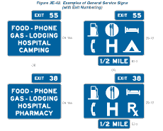
The General Service sign should contain the interchange number,
if any, as illustrated in Figure 2E-42.
Figure 2E-42 Examples of General Service Signs (with Exit Numbering)
Option:
If the distance to the next point where services are available is
greater than 16 km (10 miles), a NEXT SERVICES XX km (XX MILES)
(D9-17) sign (see Figure 2E-43) may be used as a separate sign panel
installed below the Exit Direction sign.
Figure 2E-43 Example of Next Services Sign

Standard:
Signs for services shall conform to the format for General Service
signs (see Section 2D.45)
and as specified herein. Letter and numeral sizes shall be as shown
in Tables 2E-1 through 2E-4. No more than six general road user
services shall be displayed on one sign, which includes any appended
sign panels. General Service signs shall carry the legends for one
or more of the following services: Food, Gas, Lodging, Camping, Phone, Hospital, 24-Hour Pharmacy, or Tourist Information.
The qualified services available shall be shown at specific locations on the sign.
To provide flexibility for the future when the service might become available, the sign space normally reserved for a given service symbol or word shall be left blank when that service is not present.
Guidance:
The standard display of word messages should be FOOD and PHONE in
that order on the top line, and GAS and LODGING on the second line.
If used, HOSPITAL and CAMPING should be on separate lines (see Figure
2E-42).
Option:
Signing for DIESEL, LP-Gas, or other alternative fuel services may
be substituted for any of the general services or appended to such
signs. The International Symbol of Accessibility for the Handicapped
(D9-6) sign may be used for facilities that qualify.
Guidance:
When symbols are used for the road user services, they should be
displayed as follows:
- Six services:
- Top row—GAS, FOOD, and LODGING
- Bottom row—PHONE, HOSPITAL, and CAMPING
- Four services:
- Top row—GAS and FOOD
- Bottom row—LODGING and PHONE
- Three services:
- Top row—GAS, FOOD, and LODGING
Option:
Substitutions of other services for any of the services shown above may be made by placing the substitution in the lower right (four or six services) or extreme right (three services) portion of the sign panel. An action message or an interchange number may be used for symbol signs in the same manner as they are used for word message signs. The Diesel Fuel (D9-11) symbol or the LP-Gas (D9-15) symbol may be substituted for the symbol representing fuel or appended to such assemblies. The Tourist Information (D9-10) symbol or the 24-Hour Pharmacy (D9-20 and D9-20a) symbol may be substituted on any of the above configurations.
At rural interchange areas where limited road user services are available and where it is unlikely that additional services will be provided within the near future, a sign panel having one to three services (words or symbols) may be appended to ground mounted interchange guide signs.
Standard:
If more than three services become available at rural interchange
areas where limited road user services were anticipated, any appended
sign panel shall be removed and replaced with an independently mounted
General Service sign as described in this Section.
Option:
A separate Telephone Service (D9-1) sign may be installed if telephone
facilities are located adjacent to the route at places where public
telephones would not normally be expected.
The Recreational Vehicle Sanitary Station (D9-12) sign may be used as needed to indicate the availability of facilities designed for dumping wastes from recreational vehicle holding tanks.
In some locations, signs may be used to indicate that services are not available.
A TRUCK PARKING (D9-16) sign may be used on a separate sign panel below the other general road user services to direct truck drivers to designated parking areas.
Section 2E.52 Rest and Scenic Area Signs
Guidance:
Signing for rest areas and scenic areas should conform to the provisions
set forth in Sections 2D.42
and 2D.43.
However, the signs should be suitably enlarged for freeway or expressway
application. A roadside area that does not contain restroom facilities
should be signed to indicate the major road user service that is
provided. For example, an area with only parking should be signed
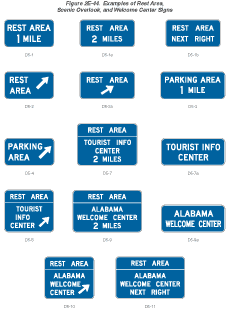
with a PARKING AREA (D5-4) sign (see Figure 2E-44). An area with
picnic tables and parking should be signed with a PICNIC AREA (D5-5c)
sign or a Picnic Table Area (D5-5a) symbol sign.
Figure 2E-44 Examples of Rest Area, Scenic Overlook, and Welcome Center Signs
Rest areas that have tourist information and welcome centers should be signed as discussed in Section 2E.53.
Scenic area signing should be consistent with that specified for rest areas. Standard messages should read SCENIC AREA (D6-1), SCENIC VIEW (D6-2), SCENIC OVERLOOK (D6-3), or the equivalent.
Standard:
All signs for rest and scenic areas shall have white letters, symbols,
and borders on a blue background. Letter and numeral sizes shall
conform to the minimum requirements of Tables 2E-1 through 2E-4.
On the approach to rest areas, a REST AREA advance guide sign shall
be placed 2 km or 1 mile and/or 4 km or 2 miles in advance of the
rest area. At the rest area exit gore, there shall be a sign with
a message REST AREA together with an arrow indicating the appropriate
turn as shown in Figure 2E-44.
Option:
If the rest area has facilities for the physically impaired (see
Section 2D.45), the International
Symbol of Accessibility for the Handicapped (D9-6) sign may be placed
with or beneath the REST AREA advance guide sign.
Between the REST AREA advance guide sign and the gore of the rest area exit, there may be a REST AREA (D5-1b) sign (see Figure 2E-44). The words NEXT RIGHT (E2-2) or an arrow may be included as part of the message.
To provide the road user with information on the location of succeeding rest areas, a NEXT REST AREA XX km (XX MILES) (D5-6) sign (see Figure 2E-44) may be installed independently or as a supplemental sign panel mounted below one of the REST AREA advance guide signs.
Section 2E.53 Tourist Information and Welcome Center Signs
Support:
Tourist information and welcome centers have been constructed within
rest areas on freeways and expressways and are operated by either
a State or a private organization. Others have been located within
close proximity to these facilities and operated by civic clubs,
chambers of commerce, or private enterprise.
Guidance:
An excessive number of supplemental panels should not be installed
with Tourist Information or Welcome Center signs so as not to overload
the road user.
Standard:
Tourist Information or Welcome Center signs (see Figure 2E-44) shall
have a white legend and border on a blue background. Continuously
staffed or unstaffed operation at least 8 hours per day, 7 days
per week, shall be required.
If operated only on a seasonal basis, the Tourist Information or Welcome Center signs shall be removed or covered during the off seasons.
Guidance:
For freeway or expressway rest area locations that also serve as
tourist information or welcome centers, the following signing criteria
should be used:
- The locations for tourist information and welcome center Advance Guide, Exit Direction, and Exit Gore signs should meet the General Service signing requirements described in Section 2E.51.
- If the signing for the tourist information or welcome center is to be accomplished in conjunction with the initial signing for the rest areas, the message on the Advance Guide sign should be REST AREA, TOURIST INFO CENTER, XX km (XX MILES) or REST AREA, WELCOME CENTER XX km (XX MILES). On the Exit Direction sign the message should be REST AREA, TOURIST INFO CENTER with an upward sloping arrow (or NEXT RIGHT), or REST AREA, WELCOME CENTER with an upward sloping arrow (or NEXT RIGHT).
- If the initial rest area Advance Guide and Exit Direction signing is in place, these signs should include, on supplemental sign panels, the legend TOURIST INFO CENTER or STATE NAME (optional), WELCOME CENTER.
- The Gore sign should contain only the legend REST AREA with the arrow and should not be supplemented with any legend pertaining to the tourist information center or welcome center.
Option:
An alternative to the supplemental TOURIST INFO CENTER legend is
the Information Symbol (D9-10) sign, which may be appended beneath
the REST AREA advance guide sign. The name of the State or local
jurisdiction may appear on tourist information/welcome center signs
if the jurisdiction controls the operation of the tourist information
or welcome center and the center meets the operating criteria set
forth herein and is consistent with State policies. The State name
may be used on the Advance Guide and the Exit Direction signs.
Guidance:
For tourist information centers located off the freeway or expressway
facility, additional signing criteria should be as follows:
- Each State should adopt a policy establishing the maximum distance that a tourist information center can be located from the interchange in order to be included on official signs.
- The location of signing should be in accordance with requirements pertaining to General Service signing (see Section 2E.51).
- Signing along the crossroad should be installed to guide the road user from the interchange to the tourist information center and back to the interchange.
Option:
As an alternative, the Information Symbol (D9-10) sign may be appended
to the guide signs for the exit providing access to the tourist
information center. As a second alternative, the Information Symbol
sign may be combined with General Service signing.
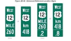
Section 2E.54 Reference Location Signs and Enhanced Reference Location Signs (D10-4, D10-5)
Support:
Reference Location (D10-1 through D10-3) signs and Intermediate
Reference Location (D10-1a through D10-3a) signs and their applications
are described in Section 2D.46.
There are two types of enhanced reference location signs:
- Enhanced Reference Location signs (D10-4), and
- Intermediate Enhanced Reference Location signs (D10-5).
Standard:
Except as provided in the option below, Reference Location (D10-1
through D10-3) signs (see Section 2D.46) shall be placed on all
expressway facilities that are located on a route where there is
a reference location sign continuity and on all freeway facilities
to assist road users in estimating their progress, to provide a
means for identifying the location of emergency incidents and traffic
crashes, and to aid in highway maintenance and servicing.
Option:
Enhanced Reference Location (D10-4) signs (see Figure 2E-45), which
enhance the reference location sign system by identifying the route,
may be placed on freeways or expressways (instead of Reference Location
signs) or on conventional roads.
To augment an enhanced reference location sign system, Intermediate Enhanced Reference Location (D10-5) signs (see Figure 2E-45), which show the tenth of a kilometer (mile) with a decimal point, may be installed along any section of a highway route or ramp at one tenth of a kilometer (mile) intervals, or at some other regular spacing.
Figure 2E-45 Enhanced Reference Location Signs
Standard:
If enhanced reference location signs are used, they shall be vertical
panels having blue or green backgrounds with white numerals, letters,
and borders, except for the route shield, which shall be the standard
color and shape. The top line shall consist of the cardinal direction
for the roadway. The second line shall consist of the applicable
route shield for the roadway. The third line shall identify the
kilometer (mile) reference for the location and the bottom line
of the Intermediate Enhanced Reference Location sign shall give
the tenth of a kilometer (mile) reference for the location. The
bottom line of the Intermediate Enhanced Reference Location sign
shall contain a decimal point. The height of the legend on enhanced
reference location signs shall be a minumum of 150 mm (6 in). The
height of the route shield on enhanced reference location signs
shall be a minimum of 300 mm (12 in).
The background color shall be the same for all enhanced reference location signs within a jurisdiction.
The design details for enhanced reference location signs shall be as shown in the "Standard Highway Signs" book (see Section 1A.11).
Enhanced reference location signs shall have a minimum mounting height of 1.2 m (4 ft) to the bottom of the sign in accordance with the mounting height requirements of delineators (see Section 3D.04), and shall not be governed by the mounting height requirements prescribed in Section 2A.18.
The distance numbering shall be continuous for each route within any State, except where overlaps occure (see Section 2E.28). Where routes overlap, enhanced reference location sign continuity shall be established for only one of the routes. If one of the overlapping routes is an Interstate route, that route shall be selected for continuity of distance numbering.
The distance measurement shall be made on the northbound and eastbound roadways. The enhanced reference location signs for southbound or westbound roadways shall be set at locations directly opposite the enhanced reference location signs for the northbound or eastbound roadways.
Guidance:
The route selected for continuity of distance numbering should also
have continuity in interchange exit numbering (see Section 2E.28).
On a route without enhanced reference location sign continuity,
the first enhanced reference location sign beyond the overlap should
indicate the total distance traveled on the route so that road users
will have a means of correlating their travel distance between enhanced
reference location signs with that shown on their odometer.
Standard:
Except as provided in the option below, enhanced reference location
signs shall be installed on the right side of the roadway.
Option:
Where conditions limit or restrict the use of enhanced reference
location signs on the right side of the roadway, they may be installed
in the median. In urban areas, Intermediate Enhanced Reference Location
signs may be installed on the right side of the roadway, in the
median, or on ramps to replace or to supplement the reference location
signs. Enhanced Reference Location signs may be installed back-to-back
in median locations.
Section 2E.55 Miscellaneous Guide Signs
Support:
Miscellaneous Guide signs are used to point out geographical features,
such as rivers and summits, and other jurisdictional boundaries
(see Section 2D.48).
Option:
Miscellaneous Guide signs may be used if they do not interfere with
signing for interchanges or other critical points.
Guidance:
Miscellaneous Guide signs should not be installed unless there are
specific reasons for orienting the road users or identifying control
points for activities that are clearly in the public interest. If
Miscellaneous Guide signs are to be of value to the road user, they
should be consistent with other freeway or expressway guide signs
in design and legibility. On all such signs, the design should be
simple and dignified, devoid of any tendency toward flamboyant advertising,
and in general conformance with other freeway and expressway signing.
Section 2E.56 Radio Information Signing
Option:
Radio-Weather Information (D12-1) signs may be used in areas where
difficult driving conditions commonly result from weather systems.
Radio-Traffic Information signs may be used in conjunction with
traffic management systems.
Standard:
Radio-Weather and Radio-Traffic Information signs shall have a white
legend and border on a blue background. Only the numerical indication
of the radio frequency shall be used to identify a station broadcasting
travel-related weather or traffic information. No more than three
frequencies shall be shown on each sign. Only radio stations whose
signal will be of value to the road user and who agree to broadcast
either of the two items below shall be identified on Radio-Weather
and Radio-Traffic Information signs:
- Periodic weather warnings at no more than 15-minute intervals during periods of adverse weather; or
- Driving condition information (affecting the roadway being traveled) at a rate of at least once every 15 minutes, or when required, during periods of adverse traffic conditions, and when supplied by an official agency having jurisdiction.
If a station to be considered operates only on a seasonal basis, its signs shall be removed or covered during the off season.
Guidance:
The radio station should have a signal strength to adequately broadcast
110 km (70 mi) along the route. Signs should be spaced as needed
for each direction of travel at distances determined by an engineering
study. The stations to be included on the signs should be selected
in cooperation with the association(s) representing major broadcasting
stations in the area to provide: (1) maximum coverage to all road
users on both AM and FM frequencies; and (2) consideration of 24
hours per day, 7 days per week broadcast capability.
Option:
In roadway rest area locations, a smaller sign using a greater number
of radio frequencies, but of the same general design, may be used.
Standard:
Radio-Weather and Radio-Traffic Information signs installed in rest
areas shall be positioned such that they are not visible from the
main roadway.
Option:
A Channel 9 Monitored (D12-3) sign or cellular phone sign may be
installed as needed.
Standard:
Only official public agencies or their designee shall be shown as
the monitoring agency on the Channel 9 Monitored sign.
Support:
Section 2D.45 contains information
about the use and application of TRAVEL INFO CALL 511 (D12-5) signs.
Section 2E.57 Carpool and Ridesharing Signing
Option:
In areas having carpool matching services, Carpool Information (D12-2)
signs (see Figure 2D-12) may
be provided adjacent to highways with preferential lanes or along
any other highway.
Carpool Information signs may include Internet addresses or telephone numbers of more than four characters within the legend.
Guidance:
Because this is an information sign related to road user services,
the Carpool Information sign should have a white legend and border
on a blue background.
Standard:
If a local transit logo or carpool symbol is incorporated into the
Carpool Information sign, the maximum vertical dimension of the
logo or symbol shall not exceed 450 mm (18 in).
Section 2E.58 Weigh Station Signing
Standard:
Weigh Station signing on freeways and expressways shall be the same
as that specified in Section 2D.44,
except for lettering size and the advance posting distance for the
Exit Direction sign, which shall be located a minimum of 450 m (1,500
ft) in advance of the gore.
Support:
Weigh Station sign layouts for freeway and expressway applications
are shown in the "Standard Highway Signs" book (see Section
1A.11).
Section 2E.59 Preferential Only Lane Signs
Support:
Additional guidance and standards related to the designation, operational
considerations, signing, pavement markings, and other considerations
for preferential only lanes is provided in Sections 2B.26,
2B.27,
2B.28,
2C.52,
3B.22,
and 3B.23.
Standard:
Ground-mounted advance guide signs shall be provided at least 800
m (0.5 mi) prior to the beginning or initial entry point to all
types of preferential only lanes (including barrier-separated, buffer-separated,
and concurrent flow). Ground-mounted guide signs shall be provided
at the beginning or initial entry point and at intermediate access
points to all types of preferential only lanes.
A combination of guide and regulatory signs shall be used in advance of all preferential only lanes. The advance guide signs for preferential only lanes shall be consistent with the requirements of Section 2E.30.
Reversible flow or express lanes that do not have any specific vehicle occupancy or designation restrictions shall be consistent with the requirements of Chapters 2B and 3B.
Overhead preferential only lane guide signs shall be used only as a supplement to ground-mounted preferential only lane guide signs unless an engineering study identifies that ground-mounted guide signs are not appropriate for a particular situation or location.
Either the HOV abbreviation or the diamond symbol shall appear in the legend of each preferential only lane sign at the designated entry and exit points for all types of HOV lanes (including barrier- and buffer-separated, concurrent flow, and direct access ramps) in order to alert motorists that there is a minimum allowable vehicle occupancy requirement for vehicles to use the HOV lanes and to inform them of the times during which these vehicle occupancy requirements are in effect.
Guidance:
Because consistency in signing and pavement markings for preferential
only lanes within a State or metropolitan area plays a critical
role in building public awareness, understanding, and acceptance,
and makes enforcement more effective, an engineering study should
be conducted to determine the appropriate combinations of overhead
signs, ground-mounted signs, and pavement markings for a specific
preferential only lane application.
Existing sign and bridge structures should be used to the extent practical for the installation of preferential only lane signs. Where possible, advance guide and guide signs that are provided for preferential only lanes should share sign structures spanning the preferential only lanes and the adjoining freeway facility.
The preferential only lane signing should be designed to avoid overloading the road user. Based on the importance of the sign, the following priority should be given: regulatory, advance regulatory, guide, then next exit supplemental signs.
Option:
Overhead advance guide signs and overhead guide signs may be used
in advance of, at the beginning or initial entry point, and at designated
intermediate access points to any type of preferential only lane.
Advance guide signs may be installed and located approximately 1.6
km (1 mi) and 3.2 km (2 mi) in advance of the beginning or initial
entry point to any type of preferential only lane.
Guidance:
Where conditions restrict the ability to provide more than one advance
guide sign in advance of any type of preferential only lane, the
advance guide sign that is installed should be placed at least 800
m (0.5 mi) in advance of the beginning or entry point to the preferential
only lane.
Advance destination guide signs, identifying downstream exit locations, should be installed in advance of designated entry points and along the length of access restricted preferential only lanes (such as barrier- and buffer-separated). In addition to the routes that typically appear on advance destination guide signs, these signs should also include destinations. These signs should be located based on the priority of the message, the available space, the existing signs on adjoining general purpose traffic lanes, roadway and traffic characteristics, the proximity to existing overhead signs, the ability to install overhead signs, and other unique local factors.
Option:
Advance guide signs may be provided for preferential only lanes
with unrestricted access, such as concurrent flow preferential only
lanes.
Guidance:
The use of guide signs for preferential only lanes at freeway interchanges
should conform to the regulatory and guide sign requirements established
in this Manual.
Option:
Changeable message signs may be used to supplement static signs
where travel conditions change or where multiple types of operational
strategies (such as variable occupancy requirements, vehicle types,
or pricing policies) are used and varied throughout the day or week
to manage the use of, control of, or access to preferential only
lanes.
Standard:
When changeable message signs (see Section
2A.07) are used as regulatory or guide signs for preferential
only lanes, they shall be the required sign size and shall display
the required letter height and legend format that corresponds to
the type of roadway facility and design speed.
Ground-mounted and overhead advance guide signs, guide signs, and exit signs applicable to HOV lanes and direct access ramps to HOV lanes shall contain the HOV diamond symbol in the upper left corner of the sign as shown in Figures 2E-46 through 2E-52. The diamond symbol shall not be used with lanes designated for bus or taxi traffic.
Figure 2E-46 Example of Signing for the Entrance to Barrier-Separated HOV Lanes
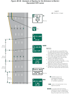
Figure 2E-47 Example of Signing for the Intermediate Entry to and Exit from Barrier- or Buffer-Separated HOV Lanes
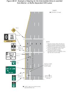
Figure 2E-48 Example of Signing for the Entrance to and Exit from an Added HOV Lane
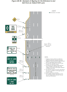
Figure 2E-49 Example of Signing for the Entrance to and Exit from a General Purpose Lane that Becomes an HOV Lane
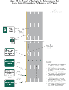
Figure 2E-50 Example of Signing for a Direct Access Ramp to an HOV Lane from a Park & Ride Facility
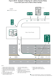
Figure 2E-51 Example of Signing for a Direct Access Ramp to an HOV Lane from a Local Street
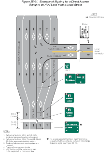
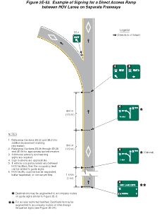
Figure 2E-52 Example of Signing for a Direct Access Ramp between HOV Lanes on Separate Freeways
Option:
Agencies may select from either the HOV abbreviation or the diamond
symbol to reference the HOV lane designation.
Guidance:
Where lateral clearance is limited, such as when a ground-mounted
Preferential Only Lane sign is installed on a median barrier, the
edges of the sign should not project beyond the outer edges of the
barrier.
Option:
Where lateral clearance is limited, Preferential Only Lane (R3-10,
R3-11, and R3-12 series) signs that are 1800 mm (72 in) or less
in width may be skewed up to 45 degrees in order to fit within the
barrier width or may be mounted at a height of 4.3 m (14 ft) or
more above the roadway.
Guidance:
Where lateral clearance is limited, Preferential Only Lane signs
that are wider than 1800 mm (72 in) should be mounted at a height
of at least 4.3 m (14 ft) above the roadway.
Standard:
For barrier-separated preferential only lanes, overhead advance
guide and overhead guide signs shall be provided in advance of and
at the beginning or initial entry point to the preferential only
lanes (see Figure 2E-46 for HOV lanes).
Overhead guide signs shall also be used at all intermediate entry
points to barrier-separated preferential only lanes (see Figure
2E-47 for HOV lanes).
For barrier-separated preferential only lanes, ground-mounted advance exit and ground-mounted exit signs shall be installed prior to and at the intermediate exit points of the preferential only lanes (see Figure 2E-47 for HOV lanes). Ground-mounted guide signs shall be mounted in the median or on median barriers that separate two directions of traffic.
Option:
For barrier-separated preferential only lanes, an advance destination
guide sign may be used in the vicinity of designated intermediate
entry and exit points.
Guidance:
For barrier-separated preferential only lanes where conditions restrict
the ability to provide more than one advance guide sign prior to
the entrance to the preferential only lane, the sign should be placed
approximately 800 m (0.5 mi) in advance of the exit. In these situations,
the installation of the corresponding regulatory and next exit supplemental
signs should be located based on the priority of the message and
the available space.
Standard:
For buffer-separated preferential only lanes (painted buffer of
0.6 m (2 ft) or more) where access is restricted to designated entry
points, ground-mounted guide signs shall be mounted in the median
or on median barriers separating two directions of traffic. Ground-mounted
advance exit and ground-mounted exit signs shall be installed prior
to and at the intermediate exit points of buffer-separated preferential
only lanes (see Figure 2E-47 for HOV lanes).
Option:
For buffer-separated preferential only lanes, an advance destination
guide sign may be used in the vicinity of designated intermediate
entry and exit points.
Guidance:
For buffer-separated HOV lanes, guide and regulatory signs should
be provided to alert HOV lane users and non-users of the minimum
allowable vehicle occupancy requirement and the locations of the
designated entry and exit points.
Standard:
For concurrent flow preferential only lanes, including those where
a preferential only lane is added to the roadway (see Figure
2E-48 for HOV lanes) and those where a general purpose lane
transitions into a preferential only lane on the roadway (see Figure
2E-49 for HOV lanes), an overhead regulatory (R3-14 or R3-14a)
sign shall be used.
For concurrent flow HOV lanes on the left side of the roadway with unrestricted access, advance guide and guide signs shall only be used on direct access ramps, such as HOV lane ramps or ramps to park & ride lots (see Figures 2E-50 and 2E-51 for HOV lanes).
For direct access ramps to HOV lanes, advance guide signs shall be provided along the adjoining surface streets to direct traffic into a transit facility (such as a park & ride lot or a transit station or terminal) that ultimately leads to HOV lanes (see Figure 2E-50 for HOV lanes).
Because direct access ramps for preferential only lanes at interchanges connecting two freeways are typically left side exits and typically have design speeds similar to the preferential only lane, overhead advance guide signs and overhead guide signs shall be provided in advance of and at the entry point to each preferential only lane ramp (see Figure 2E-52 for HOV lanes).
Support:
Figures 2E-50 through 2E-52 provide examples of recommended uses
and layouts of signs for HOV lanes for direct access ramps, park
& ride lots, access from surface streets, and exclusive preferential
only lane ramps at interchanges that directly connect two freeway
facilities. Direct access ramps to preferential only lanes sometimes
form a three or four-legged intersection that is controlled by either
static signs or traffic control signals.
The use of advance guide and guide signs for direct
access ramps for preferential only lanes at interchanges connecting
two freeways is similar to a connecting ramp between two freeway
facilities.